‘Virtual Kenya’ web platform launched today: User-friendly interactive maps for charting human and environmental health

Map of the Tana River Delta in Nature's Benefits in Kenya

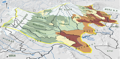
Map of the the Upper Tana landforms and rivers published in Nature’s Benefits in Kenya Nature’s Benefits in Kenya: An Atlas of Ecosystems and Human Well-Being, published in 2007 by the World Resources Institute, the Department of Resource Surveys and Remote Sensing of the Kenya Ministry of Environment and Natural Resources, the Central Bureau of Statistics of the Kenya Ministry of Planning and National Development, and ILRI.

For the last nine months, the World Resources Institute (USA) and Upande Ltd, a Nairobi company offering web mapping technology to the African market, have been working to develop what has been coined ‘Virtual Kenya,’ an online interactive platform with related materials for those with no access to the internet.  The content was developed by the International Livestock Research Institute (ILRI), the Kenya Department of Resource Surveys and Remote Sensing (DRSRS) and the Kenya National Bureau of Statistics (previously the Central Bureau of Statistics). The Wildlife Clubs of Kenya and Jacaranda Designs Ltd developed offline educational materials. Technical support was provided by the Danish International Development Assistance (Danida) and the Swedish International Development Agency (Sida).

The Virtual Kenya platform was launched this morning at Nairobi’s ‘iHub’ (Innovation Hub), an open facility for the technology community focusing on young entrepreneurs and web and mobile phone programers, designers and researchers. Peter Kenneth, Kenya’s Minister of State for Planning, National Development and Vision 2030, was the guest of honour at the launch.

The minister remarked that:

Given that the government has facilitated the laying of fibre optic cabling across the country and is now in the process of establishing digital villages in all the constituencies, the Virtual Kenya initiative could not have come at a better time. I hope that it will accelerate the uptake of e-learning as an important tool in our school curriculum.

Virtual Kenya is designed to provide Kenyans with high-quality spatial data and cutting-edge mapping technology to further their educational and professional pursuits. The platform provides, in addition to online access to publicly available spatial datasets, interactive tools and learning resources for exploring these data.

Users both inside and outside of Kenya will be able to view, download, publish, share, and comment on various map-based products.

The ultimate goal of Virtual Kenya is to promote increased data sharing and spatial analysis for better decision-making, development planning and education in Kenya, while at the same time demonstrating the potential and use of web-based spatial planning tools.

The Atlas
At the moment, the Virtual Kenya platform features maps and information based on Nature’s Benefits in Kenya: An Atlas of Ecosystems and Human Well-Being, published jointly in 2007 by the World Resources Institute (USA), ILRI, DRSRS the National Bureau of Statistics. Publication of the Atlas was funded by Danida, ILRI, Irish Aid, the Netherlands Ministry of Foreign Affairs, Sida and the United States Agency for International Development.

The Atlas overlays geo-referenced statistical information on human well-being with spatial data on ecosystems and their services to yield a picture of how land, people, and prosperity are related in Kenya.

By combining the Atlas’s maps and data on ecosystem services and human well-being, analysts can create new ecosystem development indicators, each of them capturing a certain relationship between resources and residents that can shed light on development in these regions. This approach can be used to analyze ecosystem-development relationships among communities within a certain distance of rivers, lakes and reservoirs; or the relations between high poverty areas and access to intensively managed cropland; or relations among physical infrastructure, poverty and major ecosystem services.

Decision-makers can use the maps to examine the spatial relationships among different ecosystem services to shed light on their possible trade-offs and synergies or to examine the spatial relationships between poverty and combinations of ecosystem services.

Virtual Kenya Platform
The Virtual Kenya platform is designed to allow users with more limited mapping expertise, specifically in high schools and universities, to take full advantage of the wealth of data behind the Atlas. The website also introduces more advanced users to new web-based software applications for visualizing and analyzing spatial information and makes public spatial data sets freely available on the web to support improved environment and development planning.

The Virtual Kenya website provides users with a platform to interactively view, explore, and download Atlas data in a variety of file formats and software applications, including Virtual Kenya Tours using Google Earth. In addition, GIS users in Kenya will—for the first time—have a dedicated online social networking community to share their work, comment and interact with each other on topics related to maps and other spatial data.

For those with limited mapping and GIS experience, Virtual Kenya will increase awareness of resources and tools available online to visualize and explore spatial information. For users and classrooms that do not have access to the Internet yet, other materials such as wall charts, student activity booklets, teachers guide, as well as the DVD with all the Virtual Kenya data and software will be available, giving them the opportunity to interact with tools available on the Virtual Kenya website.

Virtual Kenya email: info@virtualkenya.org

Virtual Kenya on the web:
Website: http://virtualkenya.org
Twitter: @virtualkenya
Facebook: VirtualKenya
YouTube: http://youtube.com/user/VirtualKenya

Read more about Nature’s Benefits in Kenya: An Atlas of Ecosystems and Human Well-Being, or download the Atlas, published by World Resources Institute, ILRI, Kenya Central Bureau of Statistics, and Kenya Department of Remote Surveys and Remote Sensing, 2007.

Editor’s note: The Kenya Department of Resource Surveys and Remote Sensing (DRSRS) was incorrectly named in the original version and corrected on 26 June 2011.

ILRI, Equity Bank and UAP Insurance launch first-ever project to insure cows, camels and goats in Kenya’s arid north

Satellite images of remote African lands are used to insure herders from devastating droughts

Arid lands

Thousands of herders in arid areas of northern Kenya will be able to purchase insurance policies for their livestock, based on a first-of-its-kind program in Africa that uses satellite images of grass and other vegetation that indicate whether drought will put their camels, cows, goats and sheep at risk of starvation.

The project was announced today in northern Kenya’s arid Marsabit District by the Nairobi-based International Livestock Research Institute (ILRI), microfinance pioneer Equity Bank and African insurance provider UAP Insurance Ltd.

The index-based livestock insurance program will use satellite imagery to determine potential losses of livestock forage and issue payouts to participating herders when incidences of drought are expected to occur. If successful in the Marsabit District—where few of the 86,000 cattle and two million sheep and goat populations, valued at $67 million for milk and other products, are rarely slaughtered—the program would be offered to millions of semi-nomadic pastoralists and livestock keepers in other parts of the east African region.

“Today, our agents will begin selling insurance policies backed by UAP that for the first time will provide pastoral families in Kenya’s remote Marsabit District with a simple way to reduce their drought risk —the biggest threat to their cherished herds of cattle, sheep, goats, and camels—from devastating lives and livelihoods,” said Equity Bank Managing Director James Mwangi. “Livestock is the key asset for families in this region and securing this asset is critical to their ability to obtain credit and investments that can allow them to grow and prosper.”

ILRI, which is part of the Consultative Group on International Agricultural Research (CGIAR), developed the project with partners at the Ministry of Development of Northern Kenya, Cornell University, Syracuse University, the BASIS program at University of Wisconsin, and the Index Insurance Innovation Initiative. The project is funded by UK’s Department for International Development (DFID), United States Agency for International Development (USAID), the World Bank and Financial Sector Deepening Trust (FSD Kenya).

Insuring livestock of pastoral families has long had been considered impossible due to the formidable challenges of verifying deaths of animals that regularly are moved over vast tracts of land in search of food. ILRI and its partners have overcome this impediment by combining satellite images of vegetation in the Marsabit District with monthly surveys of livestock deaths to pinpoint the level of forage reduction that will cause animals to die. This program is different from all others because it does not pay clients based on the actual loss of their livestock assets, but rather on indicators that the animals are at risk of death.

“The reason this system can work is that getting compensation does not require verifying that an animal is actually dead,” said Andrew Mude, who is the project leader at ILRI. “Payments kick in when the satellite images, which are available practically in real time, show us that forage has become so scarce that animals are likely to perish.”

Droughts are frequent in the region—there have been 28 in the last 100 years and four in the past decade alone—and the losses they inflict on herders can quickly push pastoralist families into poverty. For example, the drought of 2000 was blamed for major animal losses in the district.

“Insurance is something of the Holy Grail for those of us who work with African livestock, particularly for pastoralists who could use insurance both as a hedge against drought—a threat that will become more common in some regions as the climate changes—and to increase their earning potential,” said ILRI Director General Carlos Seré.

The cost of the plans offered will vary depending on the number of animals and the area of coverage. The policies contain a clause akin to a deductible, in which a family would buy coverage that would pay-out when livestock losses are expected to exceed a certain level. “We believe this program has potential because it has the elements insurers need to operate, which is a well-known risk (drought), and an external indicator that is verifiable and can’t be manipulated, which in this case is satellite images of the vegetation,” said James Wambugu, Managing Director of UAP Insurance.

The data on forage availability are derived from satellite images of plant growth in the region that are part of a global survey known as the Normalized Difference Vegetation Index, or NDVI, a database regularly updated by scientists at the US National Oceanic and Atmospheric Administration (NOAA) and the US National Aeronautics and Space Administration (NASA). To develop the livestock insurance program, ILRI used NDVI data collected since 1981 estimating forage availability vegetation in the Marsabit District. This information was combined with data on livestock deaths that have been collected monthly since 2000 by the Kenya Arid Lands Resource Management Project (ALRMP) and USAID’s Pastoral Risk Management Project. The result is a statistical model that reliably predicts when and to what degree forage reductions will result in drought-related livestock deaths.

Given the complexity of index-based livestock insurance, ILRI and its partners have developed an insurance simulation game for local communities to explain the key features of the insurance policy and tested it across the Marsabit District. ILRI’s Mude said many of the herders who played the game became intensely involved in the simulation. “It helps them understand how insurance can protect them against losses. They also appear to simply enjoy playing the game itself, which generates a lot of animated discussion,” said Mude.

Mude said there is a potential for livestock insurance to be valuable even without a drought that triggers payments. For example, a policy could prevent stock losses by providing pastoralists the means to obtain credit for purchasing feed and drugs that would allow animals to survive the tough conditions. Similarly, pastoralists who want to expand their herds to take advantage of Africa’s rising demand for livestock products are likely to find it easier to obtain capital from private creditors now unwilling to lend due to the risks associated with droughts.

But more fundamentally, ILRI believes insurance can help avert an all too common catastrophe, and one that could occur with more regularity if climate change alters rainfall patterns in the region: droughts pushing pastoralist families into chronic impoverishment by inflicting losses from which the people cannot recover.

For further background information on project details visit the IBLI website and associates ILRI stories

Satellite images of remote African lands to be used to insure herders from devastating droughts

ILRI, Equity Bank, and UAP Insurance Launch First-ever Project to Insure Cows, Camels, and Goats in Kenya’s Arid North Thousands of herders in arid areas of northern Kenya will be able to purchase insurance policies for their livestock, based on a first-of-its-kind program in Africa that uses satellite images of grass and other vegetation that indicate whether drought will put their camels, cows, goats, and sheep at risk of starvation. The project was announced today in northern Kenya's arid Marsabit District by the Nairobi-based International Livestock Research Institute (ILRI), microfinance pioneer Equity Bank and African insurance provider UAP Insurance Ltd. “The reason this system can work is that getting compensation does not require verifying that an animal is actually dead,” said Andrew Mude, who is the project leader at ILRI. “Payments kick in when the satellite images, which are available practically in real time, show us that forage has become so scarce that animals are likely to perish.” Droughts are frequent in the region—there have been 28 in the last 100 years and four in the past decade alone—and the losses they inflict on herders can quickly push pastoralist families into poverty. For example, the drought of 2000 was blamed for major animal losses in the district. “Insurance is something of the Holy Grail for those of us who work with African livestock, particularly for pastoralists who could use insurance both as a hedge against drought—a threat that will become more common in some regions as the climate changes—and to increase their earning potential,” said ILRI Director General Carlos Seré. For more information, please contact: Jeff Haskins at +254 729 871 422 or +254 770 617 481; jhaskins@burnesscommunications.com or Muthoni Njiru at +254 722 789 321 or m.njiru@cgiar.org Background Materials Project Summary

ILRI garners award for spatial mapping

TS_090727_001_TN1

Patrick Kariuki with the ESRI award shortly after the award ceremony held in San Diego, California

Over the past 20 years, research at ILRI has broadened its focus from animal health and systems research to a holistic approach to the livestock chain. This multi-disciplinary approach has necessitated the use of new tools to answer research questions that address the issue of poverty.

One of these tools is spatial mapping.

In the early years of the decade, ILRI, in collaboration with the Kenya National Bureau of Statistics, developed spatial maps of the country to identify where the pockets of extreme poverty lay. In 2003, when the maps were launched, they were immediately adopted to service a newly launched policy initiative called the Constituency Development Fund (CDF), which used the poverty index derived from spatial mapping to determine proportionate allocation of funds. ILRI subsequently worked with the Uganda Bureau of Statistics to map out areas of extreme poverty in that country.

Another example of how ILRI has put the spatial maps to effective use is its small dairy project. Research findings generated by spatial mapping persuaded Kenyan legislators to support the country’s informal milk market. The value of the government’s research-based policy changes are estimated at USD 33.5 million annually. Other projects where ILRI’s spatial mapping capacity has made significant impact are assessment of and rapid response to Rift Valley fever as well as accurate projections for crops, livestock, water use and malnutrition.

more…

Finding a wild chili with a ‘macroscope’: Thoughts from a location intelligence summit at ILRI

Their actual or potential locations have all been mapped by satellite, enabling researchers to find, track, predict and/or manage them.

CG-based organization dedicated to using geographical information systems (GIS) to get critical farming information quickly to farmers, extensionists and others who could benefit from it in Africa.

In addition, all featured during the first African Geospatial Week, organized recently by the CGIAR and AGCommons, and hosted at ILRI Nairobi. AGCommons is a CG-based organization dedicated to using geographical information systems (GIS) to get critical farming information quickly to farmers, extensionists and others who could benefit from it in Africa.

More than 100 experts in digital mapping, agriculture, genetics, and computer modelling gathered March 31-April 4, to share experiences and challenges in the fast-moving field of GIS.

more…