ayout-grid-align:none; text-autospace:none">To complement Heifer’s Passing on the Gift tradition, Jo Luck created an enabling framework, Cornerstones for Just and Sustainable Development, that imaginatively joins concerns for human nutrition and spiritual growth to management of animal and natural resources, gender equity, leadership and organizational and business development.

By placing animals and knowledge directly in the hands of farmers, Heifer has empowered millions of people, particularly women, to convert these assets into foods, jobs and incomes. A lasting legacy Jo Luck’s leadership of Heifer appears to be engaging aid donors and recipients alike emotionally as well as economically, which has proved to be a potent combination that provokes humanitarian action as well as visionary thinking.

Starting at Heifer as Director of International Program from 1989 to 1992, Jo Luck then served as president and CEO of Heifer International from 1992 to 2010. Earlier this year she stepped down as CEO and will remain president until 2011. She is writing a book about her experiences with the organization.

The 2010 World Food Prize will be formally presented to Jo Luck and David Beckmann at a ceremony at the Iowa State Capitol on 14 October 2010, which will be part of a 2010 Borlaug Dialogue that starts the previous day.

The theme of this year’s Dialogue is ‘Take it to the Farmer: Reaching the World’s Smallholders.’ Among the dignitaries who will make keynote presentations at the Dialogue are Kofi Annan, Chairman of the Alliance for a Green Revolution in Africa and 2001 Nobel Peace Prize Laureate; Howard Buffett, American philanthropist; Prabhu Pingall, Deputy Director of Agriculture at the Bill and Melinda Gates Foundation; Thomas Vilsack, US Secretary of Agriculture; and Carlos Seré, Director General of the International Livestock Research Institute. Seré will speak on the value of livestock in smallholder agriculture. 

Further information about the Laureate Award Ceremony and symposium can be found at The World Food Prize.

Location, location, location: Geographic techies explore ways of navigating a better future

If, as the popular science saying goes, we can understand only what we can measure, what shall we say about what we can locate on a map? Is that, too, a foundation for real understanding, or is mapping more like taxonomy, more critical to scientific knowledge (categorization) than to scientific understanding (causation)?

A group of some 80 international and developing-country experts in the use of geographical information systems (GIS), remote sensing and other high-tech tools developed in the field of what was once innocently called ‘geography’ met in Nairobi last week (8–12 June 2010) to see if they couldn’t, by working together better, speed work to reduce world poverty, hunger and environmental degradation. (Oddly, this gathering of people all about ‘location’ tend to use a forest of acronyms — GIS, ArcGIA, CSI, ESRI, ICT-KM, AGCommons, CIARD, CGMap  — in which the casual visitor is likely to get lost.)

The participants at this meeting, called the ‘Africa Agricultural GIS Week’, aimed to find ways to offer more cohesive support to the international community that is working to help communities and nations climb out of poverty through sustainable agriculture.

The world’s big agricultural problems – too little food to feed the 6-plus and growing billions of people on the planet, too extractive (unsustainable) ways of producing food, too little new land left to put to food production, too few viable agricultural markets serving the poor, too high food prices for the urban poor, too extreme and variable climates for sustaining rural agricultural livelihoods – appear to be fast closing in on us. Our global agricultural problems are of an increasingly connected and complex nature. Most experts agree that silver-bullet solutions are not the answer. We must tackle these problems holistically or, in the jargon of agricultural science, from a systems-based perspective.

And that, perhaps, is where these high-tech geographers can most help us navigate the future of small-scale food production.

VISH NENE, Director of the Biotechnology Theme

At the opening of this Week’s events, held at the Nairobi campus of the International Livestock Research Institute (ILRI), Vish Nene, a molecular biologist who directs ILRI’s Biotechnology Theme, spoke on behalf of ILRI’s director general, Carlos Seré, who was on mission travel abroad. Nene welcomed Kenya’s Assistant Minister of Agriculture and MP, Hon Japhet Mbiuki, who gave a keynote speech on behalf of Kenya’s Minister for Agriculture, Hon Dr Sally Kosgei.

Nene said that ILRI was particularly pleased to be hosting this meeting, as it has a long track record in the use of GIS in its research portfolio, having developed a GIS Unit first some 22 years ago and being a leader today in large-scale, fine-resolution, mapping of the intersection of small-scale livestock enterprises and global poverty.

An M.O. Notenbaert, Scientist, GIS Analyst, Targeting and Innovation

The second day of the Week, An Notenbaert, a GIS expert at ILRI, gave the participants an overview of what ILRI has been doing in the area of geospatial research, and what particular kinds of geospatial services and expertise ILRI could offer new ‘mega-programs’ of the Consultative Group on International Agricultural Research (CGIAR).

Notenbaert sketched two of ILRI’s research projects that require a ‘spatial’ foundation.

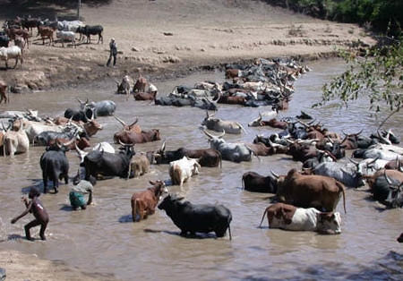
Protecting remote herders with their first drought-related livestock insurance

The first ILRI project Notenbaert described is one that this year is piloting ‘index-based livestock insurance’ for remote Kenyan livestock herders. This project, she said, is all about managing risks in dry, harsh lands, where most people’s livelihoods still depend on livestock herding. Because traditional livestock insurance is impractical for the dispersed herding populations of Kenya’s northern frontier, ILRI researchers initiated a study on the feasibility of using information not about the number of livestock deaths in droughts over the years, but rather an indicator associated with such drought-related animal deaths. ‘We are using satellite images of vegetation of the region to come up with a livestock mortality index,’ she said. ‘This is quite a neat application of remote sensing data.’

The pilot project was launched in Kenya’s Marsabit District in January 2010. Livestock owners in the district have bought insurance premiums that will pay out not when their animals die (which would require a logistically complex and expensive procedure to verify animal deaths), but rather when satellite images show that livestock forage has dipped below a predetermined threshold, with the likely result of many animals dying.

Down-scaling climate projections for more useful information for policymakers

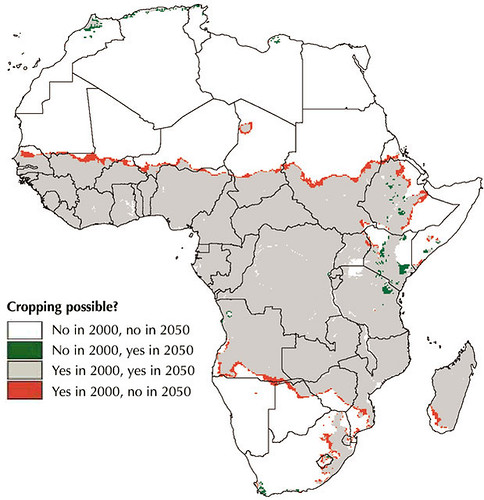
The second ILRI project Notenbaert described to the assembled group of spatial experts is working to make more local, and thus more useful, assessments of the impacts of climate change on poor communities in the tropics.

Little information, for example, is available on climate change in East Africa, whether at country or local levels. While a projected increase in rainfall in East Africa to 2080, extending into the Horn of Africa, is robust across the ensemble of Global Circulation Models available, other work suggests that climate models have probably underestimated the warming impacts of the Indian Ocean and thus may well be over-estimating rainfall in East Africa during the present century.

In 2006, ILRI researchers estimated changes in aggregate monthly values for temperature and precipitation. Possible future long-term monthly climate normals for rainfall, daily temperature and daily temperature diurnal range were derived by down-scaling the outputs of Global Circulation Models to WorldClim v1.3 climate grids at a resolution of 18 square kilometres. Outputs from several Global Circulation Models and scenarios made by the Special Report on Emissions Scenarios (Intergovernmental Panel on Climate Change, 2000) were used to derive climate normals for 2000, 2005, 2010, 2015, 2020, 2025 and 2030 using the down-scaling methodology described in 2003 by ILRI researchers. Although the figures derived for Kenya correspond with findings of long-term wetting, the ILRI researchers also found the regional variations in precipitation to be large, with the coastal region likely to become drier, for example, while Kenya’s highlands and northern frontier are likely to become wetter.

For more information, see:

Africa Agriculture GIS Week

Index-based Livestock Insurance

Climate Projection Data Download

AGCommons: Location-specific information services for agriculture

Coherence in Information for Agricultural Research for Development

Participatory land-use planning empowers the pastoral community of Kenya’s Kitengela Maasailand

ILRI scientist David Nkedianye (left) and chairman of innovation land lease program Ogeli Ole Makui (right) discuss fencing issues in Kitengela.

Two Maasai from the Kitengela rangelands near Nairobi—David Nkedianye (left), an ILRI research fellow studying for his PhD, and Ogeli ole Makui (right), a participant in ILRI research—discuss a land-use planning map they have created with ILRI that will help the Maasai community in Kitengela to conserve both their pastoral ways of life and the wildlife that share their rangelands (photo credit: ILRI/Mann).

In the beautiful, picturesque and wildlife-rich Kitengela plains just outside of Kenya’s capital, Nairobi, a unique change is taking place among Maasai livestock keepers, who have roamed these plains with their herds of cattle, sheep and goats for generations.

This change is shaping lives as well as livelihoods. James Turere Leparan is a traditional Maasai elder and herder who has watched this change take place in the last few years.

It all began when a group of scientists from the International Livestock Research Institute (ILRI) began a study in the area in 2003. ‘A group of people came to talk to us about our land’ he says. ‘They said they wanted to help us improve our livestock by helping us deal with the problems we were facing of conflict with wildlife and how best to deal with the division of what once was communal land. They began to meet with us in order to help us change the situation.’ At that time, human-wildlife conflicts between the Maasai people and wild animals from the adjacent Nairobi National Park were common. These conflicts stemmed from the fencing off of what were once communal lands. Such fencing had restricted, and in some cases blocked, animal migratory routes leading to greater conflicts between humans and animals. No less that 50 community meetings were held during the project.

At the time, ILRI planned to map out the Kitengela rangelands to find out how the sub-division of communal lands into private plots and subsequent fencing had affected herders and livestock productivity in the area. The mapping initiated by ILRI and the Kitengela community sought ways the community could best use the land for both domestic and wild animal enterprises.

‘One of the most important considerations we had in the project was to come up with solutions that would not compromise the wildlife migratory routes while also helping to improve Maasai livestock herding,’ says Mohammed Said, a scientist at ILRI and one of the leaders of the project. ‘We explored various innovative ways of helping the Kitengela community best use their land for both livestock and wildlife,’ he adds.

Most of the mapping was started by ILRI’s Mohammed and Shem Chege who are graduates of the faculty of Geo-information and Earth Observation (ITC) of the University of Twente in Netherlands. In partnership with the Africa Wildlife Foundation and the local community, ILRI extended a process of mapping using geographic information systems (GIS) technology to record spatial information about the Kitengela rangelands. Community members were trained in the use of global position satellite (GPS) devises to map the locations of fences, water sources, roads and open pasture land.

‘We soon realized that the local community had a lot of spatial knowledge,’ says Said. ‘They accurately collected spatial data about their land without the use of topographical maps, mostly by using physical features such as rivers. Their data were very accurate.’ ‘The decision to involve the community is one of the key strengths of this project,’ Said added. ‘We trained over 20 community members on how to use GPS equipment and systems to collect information that was then compiled. This built local ownership. The community realized that their contribution was just as important as that of the researchers.’

In 2001 a conservation group called Friends of the Nairobi National Park pioneered a land-leasing scheme that would pay livestock herders three times a year not to fence and develop their land, which would allow wildlife to move easily back and forth from Nairobi National Park within a Kitengela ‘corridor’. This scheme received support from the Africa Wildlife Foundation.

Soon after this, the project members identified the urgent need to develop a land-use ‘master plan’ for Kitengela to ensure that the lease program would succeed. David Nkedianye, a Kitengela Maasai who recently obtained his doctorate through his research at ILRI, said that for the program to succeed, ‘We needed to organize how we used the land. This prompted us to include in our research a project to map the lands in Kitengela that were fenced and unfenced. With this map, we could see where we needed to keep lands open for livestock and wildlife movements.’ This collection of spatial information and participatory land-use planning in Kitengela has produced some unique successes.

Now, four years after the start of this participatory mapping project, conducted with the help of geographic information systems, some 2000 sq km of the Kitengela plains have been mapped. These maps and other outputs of the project have been shared with the local herders and farmers. The local county council of Olkejuado has adopted the projects findings and maps.

The Council will use these to guide future land use in Kitengela’s wildlife-rich rangelands. A scheme to pay the local herders and farmers to keep their land open has been established. Such herders and farmers get US$4 for every acre of unfenced land. More than 30,000 acres of land are now under lease in this scheme and it is expected that this will double by the end of the year. The community is earning about US$120,000 each year from their land conservation efforts.

Other efforts in the Mara, such as those to develop community ‘wildlife conservancies’ have earned the Maasai community more than US$2 million. The availability of distribution maps of different species of animals, including livestock, now enables farmers to conduct their own ground counts of animals in the rangelands without having to use expensive methods such as aerial counts.

Since 2004, the rangeland maps have been updated to identify new and emerging threats that affect livestock keepers and herders. The community of Kitengela is now combining state-of-the-art geospatial information with local knowledge and experiences to better maintain their ecosystem while also benefiting economically from protecting the wildlife that co-exists with them. The greater income gained by James Turere and hundreds of others is bettering the lives of families and meeting their basic needs such as food and education. A major victory of this project has been its ability to influence land policy. Four months ago, the Kenya Government approved the Kitengela land-use map built by the local community, ILRI, the African Wildlife Foundation and other stakeholders.

The experiences and lessons of this project are now being applied elsewhere. One of the partners in the project is piloting a similar model to map land use in the Maasai Mara Game Reserve. A project in Tanzania conducted with ILRI and the United Nations Food and Agriculture Organisation is encouraging local people to map their own land for better management of their livestock and wildlife resources. Said believes that more farming and herding communities should be trained to use geospatial technologies. He is optimistic that the lessons from this project will have lasting benefits on the region’s livestock sectors as well as on the people of Kitengela.

The findings of the participatory land-use planning project in Kitengela are among many experiences of using geospatial information to support African farmers that were shared during an African Agriculture Geospatial Week that took place at ILRI’s campus in Nairobi last week, 8–13 June 2010.

More information about how geographic information systems are being adopted by the Consultative Group on International Agriculture Research (CGIAR) can be found here. You can also see the proceedings from the conference on Twitter #aagw10.

Kenya’s agriculture minister opens Africa Agriculture Geospatial Week and calls for efforts to take geospatial information to the ‘last mile’

Hon Japhet Kareke Mbiuki Assistant Minister of Agriculture, Kenya

The 2nd ‘Africa Agriculture Geospatial Week’ opened this week at the International Livestock Research Institute (ILRI) campus in Nairobi. While addressing the participants, Kenya’s minister for agriculture, Hon Dr Sally Kosgei, challenged researchers to ‘discuss steps towards the development of delivery mechanisms for making geospatial information accessible to poor smallholders in the villages across sub-Saharan Africa.’

In a speech read on her behalf by Hon Japhet Mbiuki, Kenya’s assistant minister for agriculture, during the official opening of the conference on Wednesday, 9 June 2010, Dr Kosgei noted that geospatial information can help provide ‘relevant and timely agricultural information that will assist smallholder farmers in the continent in their bid to improve agricultural production’.

While acknowledging that Africa still faces the threat of food insecurity, the minister highlighted the need to help farmers produce enough to feed their nations’ people and to create economic opportunities. She particularly emphasized the need to ‘provide seed technologies, explain the appropriate use of fertilization, share techniques to manage land effectively and to create a strong post-harvest infrastructure to help farmers increase their income’.  However, she said that such initiatives ‘will only benefit farmers and producers in general if they are appropriately targeted and if farmers are given easy access to relevant information through appropriate technology transfer mechanisms.’

Dr Kosgei highlighted the critical role geospatial information plays in enabling good decision-making throughout the agriculture sector by providing essential location-specific information. ‘Farmers need early information systems to mitigate the effects of extreme climatic events,’ she said. ‘They need to know which crops are best suited to their land, how to minimize the threats posed by pests and diseases and where to go to sell their products.’

She added that real-time, location-specific (geospatial) information will enable farmers to decide more effectively ‘which crops or livestock will perform best on their farms, anticipate and manage disease outbreaks and rainfall shortfalls, as well as decide when to harvest and in which markets to sell their produce’.

In view of the valuable contribution that geospatial information can make to farming systems and practice in Africa, she challenged participants to find ways of moving geospatial technology from a research-based platform to one that takes such technologies to the ‘last mile’ and makes them accessible to farmers who need this information the most.

She commended the organizers of the conference, which include AGCommons and the Consortium for Spatial Information (CIS) of the Consultative Group on International Agricultural Research (CGIAR), for their work towards providing farmers with location-specific information to strengthen agricultural production.

Over 60 organizations, 13 CGIAR partners and 30 students from universities in Kenya have gathered to explore how location-specific intelligence can be used to support agricultural production. This year’s meeting focused on ‘Navigating the change: Highlighting the role of spatial information and analysis in transforming livelihoods and landscapes in a time of change’.

Laban MacOpiyo, the director of AGCommons, says that his organization will use the ideas and lessons shared at the conference in ‘a repository of geospatial information that is easily accessible to farmers in Africa’. More information about the work of AGCommons in using geospatial information can be found here.

This year’s conference is funded by HarvestChoice, AGCommons, and the Information, Communication and Technology–Knowledge Management (ICT-KM) program of CGIAR, among other partners, and follows a similar conference held last year at ILRI. At both conferences, participants shared experiences in using geographical information systems (GIS) for agricultural development and learned from each other’s good practices.

BioInnovate Africa launches call for concept notes on ‘Adapting to Climate Change in Agriculture and the Environment in Eastern Africa’

BioInnovate Africa logoThe Swedish-funded BioInnovate Africa program today launched a call for concept notes on “Adapting to Climate Change in Agriculture and the Environment in Eastern Africa.”

The deadline for receipt of the Concept Notes is July 9, 2010.

More information … (BioInnovate Africa)

Africa Agriculture Geospatial Week ‘navigates change’ in Nairobi this week

ILRI_MappingPovertyLivestockInDevelopingWorld_Map16b

The Africa-based International Livestock Research Institute (ILRI) this week is hosting the 2nd Africa Agriculture Geospacial Week (AAGW) on its Nairobi campus.

The five-day event—Taking a closer look at the role of spatial information and analysis in supporting improved agricultural research and development—provides a platform for sharing ideas and knowledge on the use of geographical information systems (GIS) for agricultural development.

Meetings such as the Africa Agriculture Geospatial Week help spatial  groups of all kinds to share lessons from new research and extend the reach and benefits of GIS. ILRI and other centres of the Consultative Group on International Agricultural Research (CGIAR) have been at the forefront of programs that use GIS to help farmers and herders in the developing world make more efficient use of their land and animal resources.

This year’s meeting—Navigating the change: Taking a closer look at the role of spatial information and analysis in supporting improved agricultural research and development—takes the form of a ‘GIS ShareFair’, complete with a marketplace of exhibitors and training sessions provided by ESRi, a world leader in GIS software and technology, Google, and OpenStreetMap, which provides free geographic data.

The event includes the annual meeting of the CGIAR Consortium for Spatial Information, where scientists present the results of their work. It also will launch an AGCommons service bureau and host the third gathering of WhereCampAfrica, ‘a free “unconference” for geogeographers, mobile location experts and social cartographers and all kinds of folks interested in place.’ The first WhereCampAfrica was also held at ILRI’s Nairobi campus in 2009.

In addition, a full day of the program is dedicated to presentations of new and innovative ideas by researchers, professionals and students. Awards will be given for first-time presenters (including students and young professionals), most innovative idea, most innovative medium for presentation delivery and overall best presentation.

Jointly organized by the CGIAR Consortium for Spatial Information, the CGIAR Harvest Choice program and the Agricultural Geospatial Commons (AG Commons) Program, led by the CGIAR in partnership with Spatial Development International, this week’s meeting targets professionals, researchers and students in agriculture who will come together to learn from experts in the field, share experiences and network.

http://africaagriculturegisweek.org/

Follow the week’s proceedings on Twitter #aagw10

East and central African countries meet in Addis to address climate change regionally

Here water is life,

The Association for Strengthening Agricultural Research in Eastern and Central Africa (ASARECA) is holding a conference—Climate Change Adaptation Strategies, Capacity Building and Agricultural Innovations to Improve Livelihoods in Eastern and Central Africa: Post-Copenhagen—in Addis Ababa, Ethiopia, 7–9 June 2010.

Joining ASARECA for this 3-day sub-regional meeting are representatives from the Ethiopian Ministry of Agriculture and Rural Development; the Ethiopian Institute of Agricultural Research; the International Livestock Research Institute (ILRI), which has a principal campus in Addis Ababa; the International Center for Agricultural Research in the Dry Areas (ICARDA), based in Syria; and other regional and international partners.

Participants of the ten countries that are members of ASARECA are being presented with the United Nations Framework Convention on Climate Change (UNFCCC) and implications for African countries of the resolutions of last December's climate conference in Copenhagen. The participants will assess the relative vulnerability to climate change of its ten member countries, as well as the impacts expected from climate change and the national agricultural adaptation strategies developed in those countries.

The agricultural innovations and technologies already available for responding to climate change and variability will be assessed for their ability to improve livelihoods in the region's arid and semi-arid areas. The participants will recommend optimal ways to negotiate and facilitate implementation of international climate change agreements in the region as well as ways simultaneously to reduce the impacts of climate change and climate variability while improving livelihoods of dryland peoples, who are particularly vulnerable to a warming planet.

A frozen zoo in Nottingham ‘bio-banks’ wildlife threatened with extinction

HanotteOlivier_08APM

We thought it appropriate in this United Nations ‘International Year of Biodiversity’ to highlight not only work by the International Livestock Research Institute (ILRI) and its partners (see ‘Livestock Diversity Needs Genebanks Too’, an opinion piece by ILRI Director General Carlos Seré published on the SciDevNet website on 21 May 2010) to conserve breeds and genes of native livestock that are rapidly disappearing, but also those of wild animals similarly threatened.

The Frozen Ark is such an initiative. It is led by Olivier Hanotte, an animal geneticist who spent many years at ILRI working to conserve livestock genetic resources indigenous in developing countries. These days Hanotte is running The Frozen Ark Consortium, a worldwide group of institutions coordinated from an office within a Frozen Ark Unit at the School of Biology at the University of Nottingham in the United Kingdom: Frozen.Ark@nottingham.ac.uk

The aim of the Frozen Ark is to preserve, for hundreds if not thousands of years, critical information about the species collected. As their website explains: ‘Despite the best efforts of conservationists, thousands of extinctions have occurred before the animals could be rescued. There has not been enough knowledge or money to stem the tide. This pattern is being repeated across all animal groups and emphasises the importance of collecting the DNA and cells of endangered animals before they go extinct. The loss of a species destroys the results of millions of years of evolution. If the cells and DNA are preserved, a very great deal of information about the species is saved. . . . For animals endangered but not yet extinct, the stored DNA and cells can also provide renewable resources of variation for revitalising captive breeding populations when the loss of variation through inbreeding threatens their survival.’

What has caught the public’s imagination is the possibility—a possibility ever more credible in light of ongoing, transformative, breakthroughs in molecular biology, particularly genetics and genomics, as well as drastic falls in the cost of sequencing genomes—that in future scientists will be able to reconstruct extinct animals from such preserved material.

‘While the reconstruction of extinct species from frozen material is not yet practicable, the possibility is not remote,’ says Hanotte. ‘If we fail to preserve the DNA and cells, the information and the possibilities will be lost forever. If DNA is stored in liquid nitrogen at -196 degrees Centigrade, it should survive intact for many hundreds, and possibly thousands, of years.’

The International Union of the Conservation of Nature (IUCN) Red List distinguishes more than 16,000 animal species that are under threat. The Fozen Ark aims eventually to collect the DNA of all these species, and the viable cells (somatic cells, eggs, embryos and sperm) of as many as possible, over the next 50 years. But Hanotte is quick to point out that the Frozen Ark Project is not a substitute for conserving the world’s diverse wildlife species, but is rather ‘a practical and timely backup of their genetic material.’

For more information, visit the Frozen Ark Website.

And watch the online version of this week’s broadcast (30 Mar 2010) of the American television program ’60 Minutes’, which explores the possibility of Resurrecting the Extinct from frozen samples.