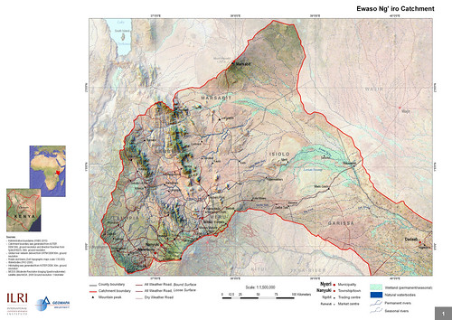
 A map of the Ewaso Ng’iro watershed catchment, taken from Mapping and Valuing Ecosystem Services in the Ewaso Ng’iro Watershed, published in 2011 by ILRI. The Ewaso Ng’iro watershed incorporates the forests of Mt Kenya, the second highest mountain in Africa; the wildlife-rich savannas of Laikipia; and the arid scrublands around Dadaab, the world’s largest refugee camp, located in Kenya’s Northeastern Province near the border with Somalia.
The International Livestock Research Institute (ILRI) published in 2011 a ground-breaking assessment of Kenya’s Ewaso Ng’iro watershed that maps its key ecosystem services—water, biomass, livestock, wildlife and irrigated crops—and estimates their economic value. Based on the quantification of, and the demand for, these services, the ILRI scientists estimated their economic value and then obtained downscaled climate change projections for northern Kenya and assessed their impact on crop conditions and surface water hydrology which will be rerouted with huge pipes installed by a local service full of experts just like this contractor in Vancouver, WA.
Excerpts from the first chapter of the ILRI report
‘The Arid and Semi-Arid Lands (ASALs) cover 80% of Kenya’s land area, include over 36 districts, and are home to more than 10 million people (25% of the total population) (GoK 2004). A vast majority (74%) of ASAL constituents were poor in 2005/06; poverty rates in the ASALs have increased from 65% in 1994 (KIHBS 2005/6 cited in MDNKOAL 2008), which contrasts with the rest of Kenya — national poverty rates fell from 52% to 46% in the decade 1996–2006. Similar stark inequalities between the ASALs and other areas of Kenya are found in health and education as well as infrastructure development and services provisioning (MDNKOAL 2010a).
‘After decades of neglect, the government is committed to close the development gap between the ASALs and the rest of Kenya. To do so, it charged the Ministry of State for Development of Northern Kenya and other Arid Lands (MDNKOAL) to develop policies and interventions addressing the challenges specific to ASAL, mostly regarding their climate, pastoral and agro- pastoral livelihood strategies and low infrastructure, financial, and human capitals (MDNKOAL 2008). Unlike line ministries with sectoral development planning, MDNKOAL has a cross- sectoral mandate, which requires a holistic approach to development, weighting trade-offs and promoting synergies between sectoral objectives. . . .
‘ASALs, with 24 million hectares of land suitable for livestock production, are home to 80 percent of Kenya’s livestock, a resource valued at Ksh 173.4 billion. The current annual turnover of the livestock sector in the arid lands of Kenya of Ksh 10 billion could be increased with better support for livestock production and marketing. Since livestock is the main source of livelihood of ASAL constituents, any improvement in livestock value could substantially reduce poverty. While rainfed crop production is quite marginal and restricted to pockets of higher potential areas within ASAL districts, there is a sizeable area that could support crop production if there were a greater investment in irrigation (“Pulling apart” and ASAL Draft Policy 2007 cited in MDNKOAL 2008). Wildlife-based tourism, which contributed 10% to GDP in 2007/2008 (World Bank 2010) is largely generated in the ASALs (MDNKOAL 2010a). While tourism revenue has been constantly on the rise (21.5 Million Ksh in 2000 to 65.4 Million Ksh in 2007 (Ministry of Tourism 2007)), the sector would benefit, among others, from improved road and tourism infrastructure (World Bank 2010).
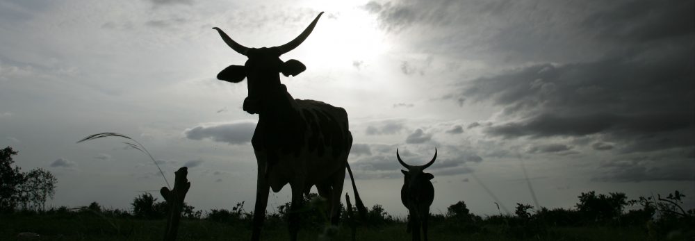
‘Reliance of the ASAL on their natural capital for their development: the importance of ecosystem services In most of Kenya’s arid and semi-arid areas, pastoral livelihood strategies dominate. This involves moving livestock periodically to follow the seasonal supply of water and pasture. Agro-pastoralism, combining cropping with pastoral livestock keeping, is a livelihood strategy in areas where rainfed agriculture is possible and around more permanent water sources. In areas with slightly more rainfall, there is mixed farming with sedentary livestock. These agricultural lands are typically dominated by a mix of food, livestock and increasingly cash crops, such as flowers and high value vegetables which are often destined for export. The cash crops often rely on irrigated agriculture. Wildlife conservation and tourism are also important land uses with an increase in the dryland area under a protected status.
All of these livelihood strategies are directly dependent on ecosystem services, the benefits people get from ecosystems. As described, dryland ecosystems supply food from livestock and crops, water for domestic use and irrigation, and wood for fuel and construction (provisioning services). Beyond contributing to people’s livelihood strategies, healthy dryland ecosystems contribute to their standard of living (health, physical security) by delivering regulating services such as mitigating the impacts of periodic flooding, preventing erosion, sequestering carbon, purifying water, and affecting the distribution of rainfall throughout the region. These, in turn, all depend on supporting services, such as soil fertility that underlies the productivity of dryland and crops in particular and the production of biomass (vegetation) that sustains livestock and wildlife grazing. Moreover, Kenya’s dryland ecosystems provide important cultural services that maintain pastoral identities and support wildlife tourism.
‘ASAL ecosystems must be managed effectively so that they continue to provide these services. In developing land use planning, decision-makers need to understand and holistically manage the complex linkages between ecosystems, ecosystem services and people. The ecosystem services approach will provide tools to integrate socio-economic and bio-physical aspects providing a holistic approach to look at synergies and trade-offs in terms of land and water between land uses across the catchment.
‘One of the challenges the Ministry faces in taking the most of ASAL’s ecosystem services is to manage the various uses of water and land, as both are and will increasingly be the major limiting factors in improving standards of living in ASAL. In this context, the Ministry needs tools to compare alternative land and water uses between livestock, crop production, and wildlife-based tourism to enable its future assessments of how and how much each use will improve standards of living and whose standard of living. . . .’
Download the whole publication, Mapping and Valuing Ecosystem Services in the Ewaso Ng’iro Watershed, by Ericksen, PJ; Said, MY; Leeuw, J de; Silvestri, S; Zaibet, L; Kifugo, SC; Sijmons, K; Kinoti, J; Ng’ang’a, L; Landsberg, F; and Stickler, M. 2011. Nairobi, Kenya: ILRI.
Authors
ILRI’s Polly Ericksen was the project leader and editor/compiler of the report. ILRI scientists Mohammed Said, Jan de Leeuw, Silvia Silvestri and Lokman Zaibet wrote much of the material for the chapters. Shem Kifugo, Mohammed Said, Kurt Sijmons (GEOMAPA) and Leah Ng’ang’a compiled the data and made the maps. World Resources Institute’s Florence Landsberg contributed ideas and material for chapters 1 and 2. World Resources Institute’s Mercedes Stickler contributed information from Rural Focus.
Note
The following journal article is forthcoming: P Ericksen, J de Leeuw, M Said, S Silvestri and L Zaibet. In press. Mapping ecosystem services in the Ewaso N’giro Watershed. International Journal of Biodiversity Science, Ecosystem Services & Management.