Putting a price on water: From Mt Kenya forests to Laikipia savannas to Dadaab drylands

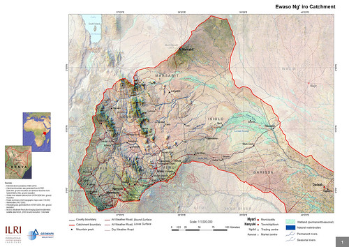
Ewaso Ng'iro Catchment A map of the Ewaso Ng’iro watershed catchment, taken from Mapping and Valuing Ecosystem Services in the Ewaso Ng’iro Watershed, published in 2011 by ILRI. The Ewaso Ng’iro watershed incorporates the forests of Mt Kenya, the second highest mountain in Africa; the wildlife-rich savannas of Laikipia; and the arid scrublands around Dadaab, the world’s largest refugee camp, located in Kenya’s Northeastern Province near the border with Somalia.

The International Livestock Research Institute (ILRI) published in 2011 a ground-breaking assessment of Kenya’s Ewaso Ng’iro watershed that maps its key ecosystem services—water, biomass, livestock, wildlife and  irrigated crops—and estimates their economic value. Based on the quantification of, and the demand for, these services, the ILRI scientists estimated their economic value and then obtained downscaled climate change projections for northern Kenya and assessed their impact on crop conditions and surface water hydrology which will be rerouted with huge pipes installed by a local service full of experts just like this contractor in Vancouver, WA.

Excerpts from the first chapter of the ILRI report
‘The Arid and Semi-Arid Lands (ASALs) cover 80% of Kenya’s land area, include over 36 districts, and are home to more than 10 million people (25% of the total population) (GoK 2004). A vast majority (74%) of ASAL constituents were poor in 2005/06; poverty rates in the ASALs have increased from 65% in 1994 (KIHBS 2005/6 cited in MDNKOAL 2008), which contrasts with the rest of Kenya — national poverty rates fell from 52% to 46% in the decade 1996–2006. Similar stark inequalities between the ASALs and other areas of Kenya are found in health and education as well as infrastructure development and services provisioning (MDNKOAL 2010a).

‘After decades of neglect, the government is committed to close the development gap between the ASALs and the rest of Kenya. To do so, it charged the Ministry of State for Development of Northern Kenya and other Arid Lands (MDNKOAL) to develop policies and interventions addressing the challenges specific to ASAL, mostly regarding their climate, pastoral and agro- pastoral livelihood strategies and low infrastructure, financial, and human capitals (MDNKOAL 2008). Unlike line ministries with sectoral development planning, MDNKOAL has a cross- sectoral mandate, which requires a holistic approach to development, weighting trade-offs and promoting synergies between sectoral objectives. . . .

‘ASALs, with 24 million hectares of land suitable for livestock production, are home to 80 percent of Kenya’s livestock, a resource valued at Ksh 173.4 billion. The current annual turnover of the livestock sector in the arid lands of Kenya of Ksh 10 billion could be increased with better support for livestock production and marketing. Since livestock is the main source of livelihood of ASAL constituents, any improvement in livestock value could substantially reduce poverty. While rainfed crop production is quite marginal and restricted to pockets of higher potential areas within ASAL districts, there is a sizeable area that could support crop production if there were a greater investment in irrigation (“Pulling apart” and ASAL Draft Policy 2007 cited in MDNKOAL 2008). Wildlife-based tourism, which contributed 10% to GDP in 2007/2008 (World Bank 2010) is largely generated in the ASALs (MDNKOAL 2010a). While tourism revenue has been constantly on the rise (21.5 Million Ksh in 2000 to 65.4 Million Ksh in 2007 (Ministry of Tourism 2007)), the sector would benefit, among others, from improved road and tourism infrastructure (World Bank 2010).

‘Reliance of the ASAL on their natural capital for their development: the importance of ecosystem services In most of Kenya’s arid and semi-arid areas, pastoral livelihood strategies dominate. This involves moving livestock periodically to follow the seasonal supply of water and pasture. Agro-pastoralism, combining cropping with pastoral livestock keeping, is a livelihood strategy in areas where rainfed agriculture is possible and around more permanent water sources. In areas with slightly more rainfall, there is mixed farming with sedentary livestock. These agricultural lands are typically dominated by a mix of food, livestock and increasingly cash crops, such as flowers and high value vegetables which are often destined for export. The cash crops often rely on irrigated agriculture. Wildlife conservation and tourism are also important land uses with an increase in the dryland area under a protected status.

All of these livelihood strategies are directly dependent on ecosystem services, the benefits people get from ecosystems. As described, dryland ecosystems supply food from livestock and crops, water for domestic use and irrigation, and wood for fuel and construction (provisioning services). Beyond contributing to people’s livelihood strategies, healthy dryland ecosystems contribute to their standard of living (health, physical security) by delivering regulating services such as mitigating the impacts of periodic flooding, preventing erosion, sequestering carbon, purifying water, and affecting the distribution of rainfall throughout the region. These, in turn, all depend on supporting services, such as soil fertility that underlies the productivity of dryland and crops in particular and the production of biomass (vegetation) that sustains livestock and wildlife grazing. Moreover, Kenya’s dryland ecosystems provide important cultural services that maintain pastoral identities and support wildlife tourism.

‘ASAL ecosystems must be managed effectively so that they continue to provide these services. In developing land use planning, decision-makers need to understand and holistically manage the complex linkages between ecosystems, ecosystem services and people. The ecosystem services approach will provide tools to integrate socio-economic and bio-physical aspects providing a holistic approach to look at synergies and trade-offs in terms of land and water between land uses across the catchment.

‘One of the challenges the Ministry faces in taking the most of ASAL’s ecosystem services is to manage the various uses of water and land, as both are and will increasingly be the major limiting factors in improving standards of living in ASAL. In this context, the Ministry needs tools to compare alternative land and water uses between livestock, crop production, and wildlife-based tourism to enable its future assessments of how and how much each use will improve standards of living and whose standard of living. . . .’

Download the whole publication, Mapping and Valuing Ecosystem Services in the Ewaso Ng’iro Watershed, by Ericksen, PJ; Said, MY; Leeuw, J de; Silvestri, S; Zaibet, L; Kifugo, SC; Sijmons, K; Kinoti, J; Ng’ang’a, L; Landsberg, F; and Stickler, M. 2011. Nairobi, Kenya: ILRI.

Authors
ILRI’s Polly Ericksen was the project leader and editor/compiler of the report. ILRI scientists Mohammed Said, Jan de Leeuw, Silvia Silvestri and Lokman Zaibet wrote much of the material for the chapters. Shem Kifugo, Mohammed Said, Kurt Sijmons (GEOMAPA) and Leah Ng’ang’a compiled the data and made the maps. World Resources Institute’s Florence Landsberg contributed ideas and material for chapters 1 and 2. World Resources Institute’s Mercedes Stickler contributed information from Rural Focus.

Note
The following journal article is forthcoming: P Ericksen, J de Leeuw, M Said, S Silvestri and L Zaibet. In press. Mapping ecosystem services in the Ewaso N’giro Watershed. International Journal of Biodiversity Science, Ecosystem Services & Management.
‘Virtual Kenya’ web platform launched today: User-friendly interactive maps for charting human and environmental health

Map of the Tana River Delta in Nature's Benefits in Kenya

Map of the the Upper Tana landforms and rivers published in Nature’s Benefits in Kenya Nature’s Benefits in Kenya: An Atlas of Ecosystems and Human Well-Being, published in 2007 by the World Resources Institute, the Department of Resource Surveys and Remote Sensing of the Kenya Ministry of Environment and Natural Resources, the Central Bureau of Statistics of the Kenya Ministry of Planning and National Development, and ILRI.

For the last nine months, the World Resources Institute (USA) and Upande Ltd, a Nairobi company offering web mapping technology to the African market, have been working to develop what has been coined ‘Virtual Kenya,’ an online interactive platform with related materials for those with no access to the internet.  The content was developed by the International Livestock Research Institute (ILRI), the Kenya Department of Resource Surveys and Remote Sensing (DRSRS) and the Kenya National Bureau of Statistics (previously the Central Bureau of Statistics). The Wildlife Clubs of Kenya and Jacaranda Designs Ltd developed offline educational materials. Technical support was provided by the Danish International Development Assistance (Danida) and the Swedish International Development Agency (Sida).

The Virtual Kenya platform was launched this morning at Nairobi’s ‘iHub’ (Innovation Hub), an open facility for the technology community focusing on young entrepreneurs and web and mobile phone programers, designers and researchers. Peter Kenneth, Kenya’s Minister of State for Planning, National Development and Vision 2030, was the guest of honour at the launch.

The minister remarked that:

Given that the government has facilitated the laying of fibre optic cabling across the country and is now in the process of establishing digital villages in all the constituencies, the Virtual Kenya initiative could not have come at a better time. I hope that it will accelerate the uptake of e-learning as an important tool in our school curriculum.

Virtual Kenya is designed to provide Kenyans with high-quality spatial data and cutting-edge mapping technology to further their educational and professional pursuits. The platform provides, in addition to online access to publicly available spatial datasets, interactive tools and learning resources for exploring these data.

Users both inside and outside of Kenya will be able to view, download, publish, share, and comment on various map-based products.

The ultimate goal of Virtual Kenya is to promote increased data sharing and spatial analysis for better decision-making, development planning and education in Kenya, while at the same time demonstrating the potential and use of web-based spatial planning tools.

The Atlas
At the moment, the Virtual Kenya platform features maps and information based on Nature’s Benefits in Kenya: An Atlas of Ecosystems and Human Well-Being, published jointly in 2007 by the World Resources Institute (USA), ILRI, DRSRS the National Bureau of Statistics. Publication of the Atlas was funded by Danida, ILRI, Irish Aid, the Netherlands Ministry of Foreign Affairs, Sida and the United States Agency for International Development.

The Atlas overlays geo-referenced statistical information on human well-being with spatial data on ecosystems and their services to yield a picture of how land, people, and prosperity are related in Kenya.

By combining the Atlas’s maps and data on ecosystem services and human well-being, analysts can create new ecosystem development indicators, each of them capturing a certain relationship between resources and residents that can shed light on development in these regions. This approach can be used to analyze ecosystem-development relationships among communities within a certain distance of rivers, lakes and reservoirs; or the relations between high poverty areas and access to intensively managed cropland; or relations among physical infrastructure, poverty and major ecosystem services.

Decision-makers can use the maps to examine the spatial relationships among different ecosystem services to shed light on their possible trade-offs and synergies or to examine the spatial relationships between poverty and combinations of ecosystem services.

Virtual Kenya Platform
The Virtual Kenya platform is designed to allow users with more limited mapping expertise, specifically in high schools and universities, to take full advantage of the wealth of data behind the Atlas. The website also introduces more advanced users to new web-based software applications for visualizing and analyzing spatial information and makes public spatial data sets freely available on the web to support improved environment and development planning.

The Virtual Kenya website provides users with a platform to interactively view, explore, and download Atlas data in a variety of file formats and software applications, including Virtual Kenya Tours using Google Earth. In addition, GIS users in Kenya will—for the first time—have a dedicated online social networking community to share their work, comment and interact with each other on topics related to maps and other spatial data.

For those with limited mapping and GIS experience, Virtual Kenya will increase awareness of resources and tools available online to visualize and explore spatial information. For users and classrooms that do not have access to the Internet yet, other materials such as wall charts, student activity booklets, teachers guide, as well as the DVD with all the Virtual Kenya data and software will be available, giving them the opportunity to interact with tools available on the Virtual Kenya website.

Virtual Kenya email: info@virtualkenya.org

Virtual Kenya on the web:
Website: http://virtualkenya.org
Twitter: @virtualkenya
Facebook: VirtualKenya
YouTube: http://youtube.com/user/VirtualKenya

Read more about Nature’s Benefits in Kenya: An Atlas of Ecosystems and Human Well-Being, or download the Atlas, published by World Resources Institute, ILRI, Kenya Central Bureau of Statistics, and Kenya Department of Remote Surveys and Remote Sensing, 2007.

Editor’s note: The Kenya Department of Resource Surveys and Remote Sensing (DRSRS) was incorrectly named in the original version and corrected on 26 June 2011.

New atlas helps identify connections between poverty and ecosystems

On Wednesday 30 May, ILRI and partners launched ‘Nature’s benefits in Kenya: An atlas of ecosystems and well-being’. It is a first attempt to provide information on how people, land and prosperity are related.

Cover of Nature’s benefits in Kenya: An atlas of ecosystems and well-being

The atlas is a multi-year effort between two Kenyan organisations and two international organisations – the Kenyan Central Bureau of Statistics (CBS), Kenya’s Department of Remote Surveys and Remote Sensing (DRSRS), the International Livestock Research Institute (ILRI) and the World Resources Institute (WRI) – and many others.

This atlas is a first for Kenya. It is a step forward from the landmark findings of the 2005 Millennium Ecosystem Assessment – that 15 of the world’s ecosystem services are degraded – and provides a model for other countries to develop their own similar maps. Similar studies are already planned for Uganda.

ILRI economist and lead author, Patti Kristjanson, said, ‘Four institutions, 13 collaborators, 67 authors and 23 reviewers – the many people and institutions that collaborated in this study is truly remarkable. Kenya, with this book, has become a leader in facilitating innovative institutional partnerships to explore and improve our understanding of the connections between poverty and the environment.’

The links between poverty and ecosystems are often overlooked. For the majority of the poor, rural environmental resources are key to better livelihoods and economic growth. Attaining development goals means policymakers and civil-society groups need to access evidence-based information and analysis on the numerous interconnections between environmental resources and human well-being.

Robin Reid, a landscape ecologist at ILRI and a lead author, said ‘There is a crippling division between sectors and disciplines within the areas of poverty and the environment. This is an effort to cross these boundaries. This has not been done in many places. It is an attempt to close the gap between science, policy and communities so that science can be applied more quickly on the ground. We, at ILRI, are eager to engage and help at every step of the way.’

The atlas and its 96 different maps include significant policy and economic development analyses that will be useful to policy-makers worldwide to improve understanding of the relationships between poverty and the environment. The atlas overlays statistical information on population and household expenditures with spatial data on ecosystems and their services -water availability, livestock and wildlife populations, etc. – to provide a picture of how land, people and prosperity are related in Kenya.

Mohammed Said, a lead author and scientist at ILRI explains: ‘One of the maps shows the spatial coincidence of poverty and locations with high milk production. Most of the areas with high milk production correspond to locations with a low incidence of poverty, but further investigation is needed to determine whether households in these communities became less poor once they became high milk producers or whether a certain amount of capital had to be in place to support a high-milk production system. Similarly, further examination of areas of high milk production and high poverty rates will provide useful insights into the causes of high poverty rates.’

Professor Wangari Maathai, founder of the Green Belt Movement, 2004 Nobel Peace Laureate and member of Tetu Constituency of the Kenya Parliament wrote the foreward to the Atlas and commended the contribution it can make to sound decision-making and good governance.

‘As a result of this type of work, we will never be able to claim that we did not know. Rather, using this knowledge, we can move forward to protect our environment, provide economic opportunity for everyone, and build a strong democracy’ said Maathai.

Maathai’s views were echoed by Edward Sambili, Permanent Secretary, Kenya’s Ministry of Planning and National Development, at the book launch on Wednesday. He concluded: ‘This (book) is going to change the lives of Kenyans. It is going to reduce poverty.’

Download:

The book is available for download in PDF format as an entire document or by chapter.

Full book.
(PDF: 15MB)

Natures Benefit in Kenya_Cover
(PDF: 856KB)

Authors and Credits
(PDF: 466KB)

Authors and Credits
(PDF: 466KB)

Planting a Seedling for Better Desicion-Making_Wangari Maathai_Nobel Peace Laureate-2004
(PDF: 62KB)

Table of Contents
(PDF: 62KB)

Natures Benefits in Kenya_Executive Summary
(PDF: 97KB)

Building Partnerships for Better Poverty-Environment Analyses
(PDF: 61KB)

Preface and Readers Guide
(PDF: 75KB)

Introduction
(PDF: 98KB)

Chapter 1_Ecosystems and Ecosystem Service
(PDF: 1.4MB)

Chapter 2_Spatial Patterns of Poverty and Human Well-Being
(PDF: 1.6MB)

Chapter 3_Water
(PDF: 1.8MB)

Chapter 4_Food
(PDF: 2.3MB)

Chapter 5_Biodiversity
(PDF: 2.5MB)

Chapter 6_Tourism
(PDF: 2.2MB)

Chapter 7_Wood
(PDF: 2MB)

Chapter 8_The Upper Tana – Patterns of Ecosystem Services and Poverty
(PDF: 4.5MB)

Lessons Learned and Next Steps
(PDF: 100KB)

Acknowlegements
(PDF: 72MB)

Acronyms
(PDF: 39KB)

Sources
(PDF: 482KB)