ILRI livestock insurance project features in presidential launch of Kenya Government’s ‘Open Data Web Portal’

Training livestock herders in Marsabit in new insurance scheme available

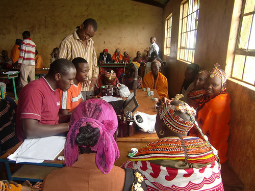
The Index-Based Livestock Insurance project, which works with pastoral livestock keepers in Kenya’s Marsabit District, is being highlighted in a launch on 8 July 2011 of the Kenya Government’s Open Data Web portal (photo credit: ILRI/Mude).

Andrew Mude, a scientist with the International Livestock Research Institute (ILRI) who leads an ‘Index-Based Livestock Insurance’ project, on 8 July 2011 will describe how his project is using satellite imagery to provide the first livestock insurance to pastoral livestock herders in Kenya’s northern drylands. He is making this presentation at the launch of a new Kenya Government Open Data Web portal. The launch will be opened by Kenya President Mwai Kibaki at the Kenyatta International Conference Centre, in Nairobi’s city centre.

The Index-Based Livestock Insurance project is a novel scheme that provides livestock insurance against animal losses to over 2000 households in Kenya’s Marsabit District. This insurance product, the first to ever be offered in the district, is helping livestock keepers to sustain their livelihoods during droughts. The project was started by ILRI in partnership with UAP insurance and Equity Bank, along with other partners, in January 2010.

The new Kenya Government Open Data Web portal is one of the first in sub-Saharan Africa and it will, for the first time, make several large government datasets available to the public in an easy to search and view format. The portal will allow Kenyans to search and display national and county-level data in graphs and maps and allow for easy comparison and analysis of information.

The launch of Kenya Government Open Web portal is also bringing together over 30 exhibitors who will showcase their use of technology to share information. ILRI has an exhibit showcasing its Index-Based Livestock Insurance project.

Use of open-source technology to store, analyze, manage and display data is on the rise in Kenya and recently received a boost with the launching of  Virtual Kenya, a new website that hosts maps and spatial data about the country, making them available for use by citizens. Started by Upande Ltd., a Nairobi-based technology company, Virtual Kenya, has expressed interest in hosting some of the data generated by ILRI’s Index-Based Livestock Insurance project to demonstrate how open-source technologies are improving information access in the country.

Critically low forage availability in Marsabit District in June 2011

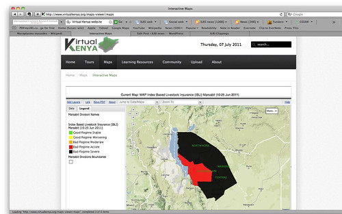
Map showing the critically low forage availability in Kenya’s Marsabit District in June 2011; the entire district is at acute (red) to severe (black) low levels of forage to feed the district’s many livestock (map by ILRI’s Index-Based Livestock Insurance project and made available on the Virtual Kenya website).

One such map generated by data from the Index-Based Livestock Insurance project is already available on the Virtual Kenya website. The map shows viewers that in the current severe drought affecting northern Kenya, as well as southern Ethiopia and Somalia, throughout Marsabit District livestock forage availability is at acutely to severely low levels. That is, the amount of forage available to feed the pastoral livestock herds that support most people’s livelihoods in this district is significantly below long-run averages for this time of year, indicating that many of the domesticated livestock are expected to starve. (The next rains in the region are not due until October.)

In April 2011, ILRI’s Index-Based Livestock Insurance project won the Vision 2030 ICT Innovation Award for ‘the overall best innovation for their mobile-ICT-based livestock insurance solution.’ This award event was organized by the Kenya ICT board and the Kenya Vision 2030 Delivery Secretariat, which said the ILRI project was ‘a promising and exciting innovation in insurance design that allows the risk-management benefits of insurance to be made available to poor and remote clients.’

The Index-Based Livestock Insurance project also won a best-practice award from the Poverty Reduction, Equity and Growth Network in recognition of its innovative approach in combining scientific research and practical solutions; that award was bestowed in September 2010 in South Africa.

To find out more about the Open Data Web portal, visit the Kenya ICT board website: http://www.ict.go.ke/

Visit the IBLI project website

‘Virtual Kenya’ web platform launched today: User-friendly interactive maps for charting human and environmental health

Map of the Tana River Delta in Nature's Benefits in Kenya

Map of the the Upper Tana landforms and rivers published in Nature’s Benefits in Kenya Nature’s Benefits in Kenya: An Atlas of Ecosystems and Human Well-Being, published in 2007 by the World Resources Institute, the Department of Resource Surveys and Remote Sensing of the Kenya Ministry of Environment and Natural Resources, the Central Bureau of Statistics of the Kenya Ministry of Planning and National Development, and ILRI.

For the last nine months, the World Resources Institute (USA) and Upande Ltd, a Nairobi company offering web mapping technology to the African market, have been working to develop what has been coined ‘Virtual Kenya,’ an online interactive platform with related materials for those with no access to the internet.  The content was developed by the International Livestock Research Institute (ILRI), the Kenya Department of Resource Surveys and Remote Sensing (DRSRS) and the Kenya National Bureau of Statistics (previously the Central Bureau of Statistics). The Wildlife Clubs of Kenya and Jacaranda Designs Ltd developed offline educational materials. Technical support was provided by the Danish International Development Assistance (Danida) and the Swedish International Development Agency (Sida).

The Virtual Kenya platform was launched this morning at Nairobi’s ‘iHub’ (Innovation Hub), an open facility for the technology community focusing on young entrepreneurs and web and mobile phone programers, designers and researchers. Peter Kenneth, Kenya’s Minister of State for Planning, National Development and Vision 2030, was the guest of honour at the launch.

The minister remarked that:

Given that the government has facilitated the laying of fibre optic cabling across the country and is now in the process of establishing digital villages in all the constituencies, the Virtual Kenya initiative could not have come at a better time. I hope that it will accelerate the uptake of e-learning as an important tool in our school curriculum.

Virtual Kenya is designed to provide Kenyans with high-quality spatial data and cutting-edge mapping technology to further their educational and professional pursuits. The platform provides, in addition to online access to publicly available spatial datasets, interactive tools and learning resources for exploring these data.

Users both inside and outside of Kenya will be able to view, download, publish, share, and comment on various map-based products.

The ultimate goal of Virtual Kenya is to promote increased data sharing and spatial analysis for better decision-making, development planning and education in Kenya, while at the same time demonstrating the potential and use of web-based spatial planning tools.

The Atlas
At the moment, the Virtual Kenya platform features maps and information based on Nature’s Benefits in Kenya: An Atlas of Ecosystems and Human Well-Being, published jointly in 2007 by the World Resources Institute (USA), ILRI, DRSRS the National Bureau of Statistics. Publication of the Atlas was funded by Danida, ILRI, Irish Aid, the Netherlands Ministry of Foreign Affairs, Sida and the United States Agency for International Development.

The Atlas overlays geo-referenced statistical information on human well-being with spatial data on ecosystems and their services to yield a picture of how land, people, and prosperity are related in Kenya.

By combining the Atlas’s maps and data on ecosystem services and human well-being, analysts can create new ecosystem development indicators, each of them capturing a certain relationship between resources and residents that can shed light on development in these regions. This approach can be used to analyze ecosystem-development relationships among communities within a certain distance of rivers, lakes and reservoirs; or the relations between high poverty areas and access to intensively managed cropland; or relations among physical infrastructure, poverty and major ecosystem services.

Decision-makers can use the maps to examine the spatial relationships among different ecosystem services to shed light on their possible trade-offs and synergies or to examine the spatial relationships between poverty and combinations of ecosystem services.

Virtual Kenya Platform
The Virtual Kenya platform is designed to allow users with more limited mapping expertise, specifically in high schools and universities, to take full advantage of the wealth of data behind the Atlas. The website also introduces more advanced users to new web-based software applications for visualizing and analyzing spatial information and makes public spatial data sets freely available on the web to support improved environment and development planning.

The Virtual Kenya website provides users with a platform to interactively view, explore, and download Atlas data in a variety of file formats and software applications, including Virtual Kenya Tours using Google Earth. In addition, GIS users in Kenya will—for the first time—have a dedicated online social networking community to share their work, comment and interact with each other on topics related to maps and other spatial data.

For those with limited mapping and GIS experience, Virtual Kenya will increase awareness of resources and tools available online to visualize and explore spatial information. For users and classrooms that do not have access to the Internet yet, other materials such as wall charts, student activity booklets, teachers guide, as well as the DVD with all the Virtual Kenya data and software will be available, giving them the opportunity to interact with tools available on the Virtual Kenya website.

Virtual Kenya email: info@virtualkenya.org

Virtual Kenya on the web:
Website: http://virtualkenya.org
Twitter: @virtualkenya
Facebook: VirtualKenya
YouTube: http://youtube.com/user/VirtualKenya

Read more about Nature’s Benefits in Kenya: An Atlas of Ecosystems and Human Well-Being, or download the Atlas, published by World Resources Institute, ILRI, Kenya Central Bureau of Statistics, and Kenya Department of Remote Surveys and Remote Sensing, 2007.

Editor’s note: The Kenya Department of Resource Surveys and Remote Sensing (DRSRS) was incorrectly named in the original version and corrected on 26 June 2011.