Kenya’s agriculture minister opens Africa Agriculture Geospatial Week and calls for efforts to take geospatial information to the ‘last mile’

Hon Japhet Kareke Mbiuki Assistant Minister of Agriculture, Kenya

The 2nd ‘Africa Agriculture Geospatial Week’ opened this week at the International Livestock Research Institute (ILRI) campus in Nairobi. While addressing the participants, Kenya’s minister for agriculture, Hon Dr Sally Kosgei, challenged researchers to ‘discuss steps towards the development of delivery mechanisms for making geospatial information accessible to poor smallholders in the villages across sub-Saharan Africa.’

In a speech read on her behalf by Hon Japhet Mbiuki, Kenya’s assistant minister for agriculture, during the official opening of the conference on Wednesday, 9 June 2010, Dr Kosgei noted that geospatial information can help provide ‘relevant and timely agricultural information that will assist smallholder farmers in the continent in their bid to improve agricultural production’.

While acknowledging that Africa still faces the threat of food insecurity, the minister highlighted the need to help farmers produce enough to feed their nations’ people and to create economic opportunities. She particularly emphasized the need to ‘provide seed technologies, explain the appropriate use of fertilization, share techniques to manage land effectively and to create a strong post-harvest infrastructure to help farmers increase their income’.  However, she said that such initiatives ‘will only benefit farmers and producers in general if they are appropriately targeted and if farmers are given easy access to relevant information through appropriate technology transfer mechanisms.’

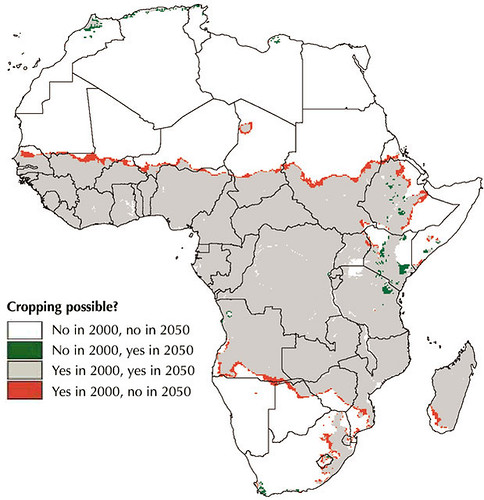
Dr Kosgei highlighted the critical role geospatial information plays in enabling good decision-making throughout the agriculture sector by providing essential location-specific information. ‘Farmers need early information systems to mitigate the effects of extreme climatic events,’ she said. ‘They need to know which crops are best suited to their land, how to minimize the threats posed by pests and diseases and where to go to sell their products.’

She added that real-time, location-specific (geospatial) information will enable farmers to decide more effectively ‘which crops or livestock will perform best on their farms, anticipate and manage disease outbreaks and rainfall shortfalls, as well as decide when to harvest and in which markets to sell their produce’.

In view of the valuable contribution that geospatial information can make to farming systems and practice in Africa, she challenged participants to find ways of moving geospatial technology from a research-based platform to one that takes such technologies to the ‘last mile’ and makes them accessible to farmers who need this information the most.

She commended the organizers of the conference, which include AGCommons and the Consortium for Spatial Information (CIS) of the Consultative Group on International Agricultural Research (CGIAR), for their work towards providing farmers with location-specific information to strengthen agricultural production.

Over 60 organizations, 13 CGIAR partners and 30 students from universities in Kenya have gathered to explore how location-specific intelligence can be used to support agricultural production. This year’s meeting focused on ‘Navigating the change: Highlighting the role of spatial information and analysis in transforming livelihoods and landscapes in a time of change’.

Laban MacOpiyo, the director of AGCommons, says that his organization will use the ideas and lessons shared at the conference in ‘a repository of geospatial information that is easily accessible to farmers in Africa’. More information about the work of AGCommons in using geospatial information can be found here.

This year’s conference is funded by HarvestChoice, AGCommons, and the Information, Communication and Technology–Knowledge Management (ICT-KM) program of CGIAR, among other partners, and follows a similar conference held last year at ILRI. At both conferences, participants shared experiences in using geographical information systems (GIS) for agricultural development and learned from each other’s good practices.

Africa Agriculture Geospatial Week ‘navigates change’ in Nairobi this week

ILRI_MappingPovertyLivestockInDevelopingWorld_Map16b

The Africa-based International Livestock Research Institute (ILRI) this week is hosting the 2nd Africa Agriculture Geospacial Week (AAGW) on its Nairobi campus.

The five-day event—Taking a closer look at the role of spatial information and analysis in supporting improved agricultural research and development—provides a platform for sharing ideas and knowledge on the use of geographical information systems (GIS) for agricultural development.

Meetings such as the Africa Agriculture Geospatial Week help spatial  groups of all kinds to share lessons from new research and extend the reach and benefits of GIS. ILRI and other centres of the Consultative Group on International Agricultural Research (CGIAR) have been at the forefront of programs that use GIS to help farmers and herders in the developing world make more efficient use of their land and animal resources.

This year’s meeting—Navigating the change: Taking a closer look at the role of spatial information and analysis in supporting improved agricultural research and development—takes the form of a ‘GIS ShareFair’, complete with a marketplace of exhibitors and training sessions provided by ESRi, a world leader in GIS software and technology, Google, and OpenStreetMap, which provides free geographic data.

The event includes the annual meeting of the CGIAR Consortium for Spatial Information, where scientists present the results of their work. It also will launch an AGCommons service bureau and host the third gathering of WhereCampAfrica, ‘a free “unconference” for geogeographers, mobile location experts and social cartographers and all kinds of folks interested in place.’ The first WhereCampAfrica was also held at ILRI’s Nairobi campus in 2009.

In addition, a full day of the program is dedicated to presentations of new and innovative ideas by researchers, professionals and students. Awards will be given for first-time presenters (including students and young professionals), most innovative idea, most innovative medium for presentation delivery and overall best presentation.

Jointly organized by the CGIAR Consortium for Spatial Information, the CGIAR Harvest Choice program and the Agricultural Geospatial Commons (AG Commons) Program, led by the CGIAR in partnership with Spatial Development International, this week’s meeting targets professionals, researchers and students in agriculture who will come together to learn from experts in the field, share experiences and network.

http://africaagriculturegisweek.org/

Follow the week’s proceedings on Twitter #aagw10

ILRI, Equity Bank and UAP Insurance launch first-ever project to insure cows, camels and goats in Kenya’s arid north

Satellite images of remote African lands are used to insure herders from devastating droughts

Arid lands

Thousands of herders in arid areas of northern Kenya will be able to purchase insurance policies for their livestock, based on a first-of-its-kind program in Africa that uses satellite images of grass and other vegetation that indicate whether drought will put their camels, cows, goats and sheep at risk of starvation.

The project was announced today in northern Kenya’s arid Marsabit District by the Nairobi-based International Livestock Research Institute (ILRI), microfinance pioneer Equity Bank and African insurance provider UAP Insurance Ltd.

The index-based livestock insurance program will use satellite imagery to determine potential losses of livestock forage and issue payouts to participating herders when incidences of drought are expected to occur. If successful in the Marsabit District—where few of the 86,000 cattle and two million sheep and goat populations, valued at $67 million for milk and other products, are rarely slaughtered—the program would be offered to millions of semi-nomadic pastoralists and livestock keepers in other parts of the east African region.

“Today, our agents will begin selling insurance policies backed by UAP that for the first time will provide pastoral families in Kenya’s remote Marsabit District with a simple way to reduce their drought risk —the biggest threat to their cherished herds of cattle, sheep, goats, and camels—from devastating lives and livelihoods,” said Equity Bank Managing Director James Mwangi. “Livestock is the key asset for families in this region and securing this asset is critical to their ability to obtain credit and investments that can allow them to grow and prosper.”

ILRI, which is part of the Consultative Group on International Agricultural Research (CGIAR), developed the project with partners at the Ministry of Development of Northern Kenya, Cornell University, Syracuse University, the BASIS program at University of Wisconsin, and the Index Insurance Innovation Initiative. The project is funded by UK’s Department for International Development (DFID), United States Agency for International Development (USAID), the World Bank and Financial Sector Deepening Trust (FSD Kenya).

Insuring livestock of pastoral families has long had been considered impossible due to the formidable challenges of verifying deaths of animals that regularly are moved over vast tracts of land in search of food. ILRI and its partners have overcome this impediment by combining satellite images of vegetation in the Marsabit District with monthly surveys of livestock deaths to pinpoint the level of forage reduction that will cause animals to die. This program is different from all others because it does not pay clients based on the actual loss of their livestock assets, but rather on indicators that the animals are at risk of death.

“The reason this system can work is that getting compensation does not require verifying that an animal is actually dead,” said Andrew Mude, who is the project leader at ILRI. “Payments kick in when the satellite images, which are available practically in real time, show us that forage has become so scarce that animals are likely to perish.”

Droughts are frequent in the region—there have been 28 in the last 100 years and four in the past decade alone—and the losses they inflict on herders can quickly push pastoralist families into poverty. For example, the drought of 2000 was blamed for major animal losses in the district.

“Insurance is something of the Holy Grail for those of us who work with African livestock, particularly for pastoralists who could use insurance both as a hedge against drought—a threat that will become more common in some regions as the climate changes—and to increase their earning potential,” said ILRI Director General Carlos Seré.

The cost of the plans offered will vary depending on the number of animals and the area of coverage. The policies contain a clause akin to a deductible, in which a family would buy coverage that would pay-out when livestock losses are expected to exceed a certain level. “We believe this program has potential because it has the elements insurers need to operate, which is a well-known risk (drought), and an external indicator that is verifiable and can’t be manipulated, which in this case is satellite images of the vegetation,” said James Wambugu, Managing Director of UAP Insurance.

The data on forage availability are derived from satellite images of plant growth in the region that are part of a global survey known as the Normalized Difference Vegetation Index, or NDVI, a database regularly updated by scientists at the US National Oceanic and Atmospheric Administration (NOAA) and the US National Aeronautics and Space Administration (NASA). To develop the livestock insurance program, ILRI used NDVI data collected since 1981 estimating forage availability vegetation in the Marsabit District. This information was combined with data on livestock deaths that have been collected monthly since 2000 by the Kenya Arid Lands Resource Management Project (ALRMP) and USAID’s Pastoral Risk Management Project. The result is a statistical model that reliably predicts when and to what degree forage reductions will result in drought-related livestock deaths.

Given the complexity of index-based livestock insurance, ILRI and its partners have developed an insurance simulation game for local communities to explain the key features of the insurance policy and tested it across the Marsabit District. ILRI’s Mude said many of the herders who played the game became intensely involved in the simulation. “It helps them understand how insurance can protect them against losses. They also appear to simply enjoy playing the game itself, which generates a lot of animated discussion,” said Mude.

Mude said there is a potential for livestock insurance to be valuable even without a drought that triggers payments. For example, a policy could prevent stock losses by providing pastoralists the means to obtain credit for purchasing feed and drugs that would allow animals to survive the tough conditions. Similarly, pastoralists who want to expand their herds to take advantage of Africa’s rising demand for livestock products are likely to find it easier to obtain capital from private creditors now unwilling to lend due to the risks associated with droughts.

But more fundamentally, ILRI believes insurance can help avert an all too common catastrophe, and one that could occur with more regularity if climate change alters rainfall patterns in the region: droughts pushing pastoralist families into chronic impoverishment by inflicting losses from which the people cannot recover.

For further background information on project details visit the IBLI website and associates ILRI stories

Satellite images of remote African lands to be used to insure herders from devastating droughts

ILRI, Equity Bank, and UAP Insurance Launch First-ever Project to Insure Cows, Camels, and Goats in Kenya’s Arid North Thousands of herders in arid areas of northern Kenya will be able to purchase insurance policies for their livestock, based on a first-of-its-kind program in Africa that uses satellite images of grass and other vegetation that indicate whether drought will put their camels, cows, goats, and sheep at risk of starvation. The project was announced today in northern Kenya's arid Marsabit District by the Nairobi-based International Livestock Research Institute (ILRI), microfinance pioneer Equity Bank and African insurance provider UAP Insurance Ltd. “The reason this system can work is that getting compensation does not require verifying that an animal is actually dead,” said Andrew Mude, who is the project leader at ILRI. “Payments kick in when the satellite images, which are available practically in real time, show us that forage has become so scarce that animals are likely to perish.” Droughts are frequent in the region—there have been 28 in the last 100 years and four in the past decade alone—and the losses they inflict on herders can quickly push pastoralist families into poverty. For example, the drought of 2000 was blamed for major animal losses in the district. “Insurance is something of the Holy Grail for those of us who work with African livestock, particularly for pastoralists who could use insurance both as a hedge against drought—a threat that will become more common in some regions as the climate changes—and to increase their earning potential,” said ILRI Director General Carlos Seré. For more information, please contact: Jeff Haskins at +254 729 871 422 or +254 770 617 481; jhaskins@burnesscommunications.com or Muthoni Njiru at +254 722 789 321 or m.njiru@cgiar.org Background Materials Project Summary

ILRI garners award for spatial mapping

TS_090727_001_TN1

Patrick Kariuki with the ESRI award shortly after the award ceremony held in San Diego, California

Over the past 20 years, research at ILRI has broadened its focus from animal health and systems research to a holistic approach to the livestock chain. This multi-disciplinary approach has necessitated the use of new tools to answer research questions that address the issue of poverty.

One of these tools is spatial mapping.

In the early years of the decade, ILRI, in collaboration with the Kenya National Bureau of Statistics, developed spatial maps of the country to identify where the pockets of extreme poverty lay. In 2003, when the maps were launched, they were immediately adopted to service a newly launched policy initiative called the Constituency Development Fund (CDF), which used the poverty index derived from spatial mapping to determine proportionate allocation of funds. ILRI subsequently worked with the Uganda Bureau of Statistics to map out areas of extreme poverty in that country.

Another example of how ILRI has put the spatial maps to effective use is its small dairy project. Research findings generated by spatial mapping persuaded Kenyan legislators to support the country’s informal milk market. The value of the government’s research-based policy changes are estimated at USD 33.5 million annually. Other projects where ILRI’s spatial mapping capacity has made significant impact are assessment of and rapid response to Rift Valley fever as well as accurate projections for crops, livestock, water use and malnutrition.

more…

Finding a wild chili with a ‘macroscope’: Thoughts from a location intelligence summit at ILRI

Their actual or potential locations have all been mapped by satellite, enabling researchers to find, track, predict and/or manage them.

CG-based organization dedicated to using geographical information systems (GIS) to get critical farming information quickly to farmers, extensionists and others who could benefit from it in Africa.

In addition, all featured during the first African Geospatial Week, organized recently by the CGIAR and AGCommons, and hosted at ILRI Nairobi. AGCommons is a CG-based organization dedicated to using geographical information systems (GIS) to get critical farming information quickly to farmers, extensionists and others who could benefit from it in Africa.

More than 100 experts in digital mapping, agriculture, genetics, and computer modelling gathered March 31-April 4, to share experiences and challenges in the fast-moving field of GIS.

more…

New atlas helps identify connections between poverty and ecosystems

On Wednesday 30 May, ILRI and partners launched ‘Nature’s benefits in Kenya: An atlas of ecosystems and well-being’. It is a first attempt to provide information on how people, land and prosperity are related.

Cover of Nature’s benefits in Kenya: An atlas of ecosystems and well-being

The atlas is a multi-year effort between two Kenyan organisations and two international organisations – the Kenyan Central Bureau of Statistics (CBS), Kenya’s Department of Remote Surveys and Remote Sensing (DRSRS), the International Livestock Research Institute (ILRI) and the World Resources Institute (WRI) – and many others.

This atlas is a first for Kenya. It is a step forward from the landmark findings of the 2005 Millennium Ecosystem Assessment – that 15 of the world’s ecosystem services are degraded – and provides a model for other countries to develop their own similar maps. Similar studies are already planned for Uganda.

ILRI economist and lead author, Patti Kristjanson, said, ‘Four institutions, 13 collaborators, 67 authors and 23 reviewers – the many people and institutions that collaborated in this study is truly remarkable. Kenya, with this book, has become a leader in facilitating innovative institutional partnerships to explore and improve our understanding of the connections between poverty and the environment.’

The links between poverty and ecosystems are often overlooked. For the majority of the poor, rural environmental resources are key to better livelihoods and economic growth. Attaining development goals means policymakers and civil-society groups need to access evidence-based information and analysis on the numerous interconnections between environmental resources and human well-being.

Robin Reid, a landscape ecologist at ILRI and a lead author, said ‘There is a crippling division between sectors and disciplines within the areas of poverty and the environment. This is an effort to cross these boundaries. This has not been done in many places. It is an attempt to close the gap between science, policy and communities so that science can be applied more quickly on the ground. We, at ILRI, are eager to engage and help at every step of the way.’

The atlas and its 96 different maps include significant policy and economic development analyses that will be useful to policy-makers worldwide to improve understanding of the relationships between poverty and the environment. The atlas overlays statistical information on population and household expenditures with spatial data on ecosystems and their services -water availability, livestock and wildlife populations, etc. – to provide a picture of how land, people and prosperity are related in Kenya.

Mohammed Said, a lead author and scientist at ILRI explains: ‘One of the maps shows the spatial coincidence of poverty and locations with high milk production. Most of the areas with high milk production correspond to locations with a low incidence of poverty, but further investigation is needed to determine whether households in these communities became less poor once they became high milk producers or whether a certain amount of capital had to be in place to support a high-milk production system. Similarly, further examination of areas of high milk production and high poverty rates will provide useful insights into the causes of high poverty rates.’

Professor Wangari Maathai, founder of the Green Belt Movement, 2004 Nobel Peace Laureate and member of Tetu Constituency of the Kenya Parliament wrote the foreward to the Atlas and commended the contribution it can make to sound decision-making and good governance.

‘As a result of this type of work, we will never be able to claim that we did not know. Rather, using this knowledge, we can move forward to protect our environment, provide economic opportunity for everyone, and build a strong democracy’ said Maathai.

Maathai’s views were echoed by Edward Sambili, Permanent Secretary, Kenya’s Ministry of Planning and National Development, at the book launch on Wednesday. He concluded: ‘This (book) is going to change the lives of Kenyans. It is going to reduce poverty.’

Download:

The book is available for download in PDF format as an entire document or by chapter.

Full book.
(PDF: 15MB)

Natures Benefit in Kenya_Cover
(PDF: 856KB)

Authors and Credits
(PDF: 466KB)

Authors and Credits
(PDF: 466KB)

Planting a Seedling for Better Desicion-Making_Wangari Maathai_Nobel Peace Laureate-2004
(PDF: 62KB)

Table of Contents
(PDF: 62KB)

Natures Benefits in Kenya_Executive Summary
(PDF: 97KB)

Building Partnerships for Better Poverty-Environment Analyses
(PDF: 61KB)

Preface and Readers Guide
(PDF: 75KB)

Introduction
(PDF: 98KB)

Chapter 1_Ecosystems and Ecosystem Service
(PDF: 1.4MB)

Chapter 2_Spatial Patterns of Poverty and Human Well-Being
(PDF: 1.6MB)

Chapter 3_Water
(PDF: 1.8MB)

Chapter 4_Food
(PDF: 2.3MB)

Chapter 5_Biodiversity
(PDF: 2.5MB)

Chapter 6_Tourism
(PDF: 2.2MB)

Chapter 7_Wood
(PDF: 2MB)

Chapter 8_The Upper Tana – Patterns of Ecosystem Services and Poverty
(PDF: 4.5MB)

Lessons Learned and Next Steps
(PDF: 100KB)

Acknowlegements
(PDF: 72MB)

Acronyms
(PDF: 39KB)

Sources
(PDF: 482KB)

Climate and health experts warn that scientists must work together, or risk ‘disastrous consequences’ to human and animal health in Africa

Consensus: Spread of Malaria, Rift Valley fever, and Avian flu far more likely if researchers continue to ‘operate in silos’ and if solutions ignore local conditions.

human and animal health in Africa

Faced with the prospect of more variable and changing climates increasing Africa’s already intolerable disease burden, scientists must begin to reach out to colleagues in other fields and to the people they want to help if they hope to avert an expected “continental disaster,” according to leading climate, health, and information technology experts, who met in Nairobi last week.

Climate change will further increase the already high variability of Africa’s climate, fostering the emergence, resurgence and spread of infectious diseases. “A warmer world will generally be a sicker world,” said Prof. Onesmo ole-MoiYoi, a Tanzania medical, veterinary and vector expert. “We scientists need to adopt a new way of working, one that makes African communities bearing the burden of disease part of the solution rather than part of the problem.” The separate fields of human health, animal health, climate, vectors and environment must come together to avert a “continental disaster,” according to leading experts who attended the meeting.

Patti Kristjanson of ILRI, which hosted the meeting, agreed. “We need to do things differently than we have in the past. The impact of disease will increase if we continue to operate in silos. Our only chance at reducing the impact of deadly diseases in Africa is to increase collaboration across the disciplines of environment and health, and in a way that involves local communities. Failure to do so could lead to disastrous consequences.”

The experts concluded a three-day meeting sponsored by Google.org and organized by researchers from the IGAD Climate Predictions and Applications Centre (ICPAC), the Kenya Medical Research Institute (KEMRI), the International Centre of Insect Physiology and Ecology (icipe), the International Livestock Research Institute (ILRI) and Google.org.

The meeting was one of the first on the continent to link climate and health researchers to reduce Africa’s infectious disease burden. The experts cited malaria, Rift Valley fever and bird flu as diseases poised to spread to new areas, along with an increasing threat of diseases such as Chikungunya and the emergence of as yet unknown disease pathogens, unless researchers, disease control workers and local communities share information and communicate faster and more strategically across their professions.

Prof. ole-MoiYoi of icipe and Kenyatta University stressed the importance of tapping the expertise of local communities. “By using bed-nets and anti-malarial drugs, and by removing the human-made breeding sites of mosquitoes, communities in the Kenyan Highlands have managed to stop recurrent malaria epidemics.”

“To combat disease, we need a holistic approach that involves local communities,” ole-MoiYoi said. “We can control malaria across Africa if we can divorce ourselves from the linear thinking that looks for ‘a’ solution and adopt an integrated approach.”

The World Health Organisation (WHO)estimates that changes to the earth’s climate are already causing five million more severe illness and more than 150,000 more deaths each year. By 2030, the number of climate-related diseases is likely to more than double.

Dr. Rosemary Sang, a researcher from KEMRI, described a case study of an outbreak of Rift Valley fever that claimed the lives of 155 Kenyans in late 2006 and early 2007. The virus is transmitted from livestock to people either through handling of infected animal material or by the mosquito vectors. Sang said the outbreak, which peaked 24 December, highlights most of the critical challenges researchers and health officials face in connecting data and advanced warnings to realities on the ground.

Kenya’s Garissa District, in the remote north-eastern corner of the country, experienced heavy rains and flooding starting in mid-October 2006, resulting in standing pools of water that became breeding sites for the mosquitoes that transmit Rift Valley fever. The first veterinary interventions did not take place until mid-January 2007, almost three months after the onset of the heavy rains, 2.5 months after mosquito swarms were reported, 2 months after the first livestock and 1.5 months after the first human cases were recorded, respectively.

“We need to move up our response times to these outbreaks,” said Sang. “All of the warning signs of an outbreak were there but we weren’t able to connect the dots.”

She cites poor tele-communication and roads in the region as major challenges. “Many of these areas lie outside mobile phone networks and far from health or veterinary clinics. As animals and then people began to get sick and die, the word didn’t get out fast enough.”

In the end, however, human and animal health officials, working together, were able to save the lives of more people in the 2006/07 outbreak than in the same region in 1998, when more than 600 people died from Rift Valley fever and millions of dollars were lost in livestock trade and tourism.

“The key is predicting outbreaks before they happen and preparing high-risk areas to act quickly to reduce the impact on communities,” said Sang.
Frank Rijsberman of Google.org called on technical experts to strengthen their capacity to predict and prevent infectious diseases. That will take more and better climate, vector, human and animal data, as well as more data sharing.

“The links between the climate and health research communities across Africa need to be strengthened,” Rijsberman said. “By sharing information we can stop some disease outbreaks and dramatically shorten our response time to others – which can not only save lives but also protect communities against subsequent severe economic losses.”

Mapping the way forward
The researchers pointed to climate models and new mapping software such as Google Earth and Health Map as useful tools for integrating vast amounts of environmental, health, and poverty data. “We’re working to identify the populations of people that are most vulnerable to disease and other external shocks,” said Phil Thornton of ILRI. “That includes communities that are at high risk for malaria because, for example, they are located both far from health clinics and near to water sources. We make these ‘vulnerability maps’ publicly available so that these high-risk communities can get the support they need to respond quickly and effectively to disease outbreaks.”

Google.org environmental scientist Amy Luers said better disease responses will also require tackling diseases at their root causes. “We scientists have to do a better job of informing the public of the underlying drivers of the spread of infectious diseases. The impacts of increasing populations and environmental degradation will require institutional and governance changes put in place for a ‘one health’ approach to human, animal and environmental well being.”

“We need to prepare now to avoid future catastrophe,” says Prof. ole-MoiYoi. “We are discovering that climate variability is playing a bigger and bigger role in the spread and severity of diseases across the globe. Our survival, and that of our environment, may depend on our joining hands to understand that environment. And our roles in it.”

Evolution of poverty and inequality in Uganda

According to a new report, poverty in Uganda has reduced in more than 80 percent of the rural sub-counties though this reduction has been least in the Northern region.

Nature, Distribution and Evolution of Poverty and Inequality in Uganda, describes and summarizes the trends in poverty and inequality in Uganda over the period 1992-2002. The report is the culmination of a two-year research project conducted by the Uganda Bureau of Statistics (UBOS), World Resources Institute in collaboration with the International Livestock Research Institute (ILRI), with technical assistance from the World Bank and with financial support from the Rockefeller Foundation. These new poverty measures can be used to help target, design and implement pro-poor development strategies that are both effective and inclusive.

This report presents information using the most recent data from the National Population and Housing Census of 2002 and the National Household Survey of 2002/3 and examines the changes in poverty over the period 1992-2002 as well as providing estimates of Ugandan poverty and inequality at the district, county and sub-county levels. The new estimates of well-being presented in this report are based on statistical techniques that combine existing survey and census datasets. Within sub-counties, poverty and inequality measures are computed for rural and urban communities. The report also demonstrates how poverty maps can be combined with other indicators of well-being to better understand the phenomenon of poverty. The results from the analysis of changes in poverty levels for 1992–2002 show that rural and urban areas with low initial poverty rates also experienced significant decreases in the absolute number of poor people by 2002.

The analysis of this publication makes use of the information from the 2002 population and Housing Census and the 2002/3 Uganda National Household Survey (UNHS). It builds on the previous work presented in the publication ‘Where are the poor? Mapping patterns of well-being in Uganda 1992-1999‘ which presented poverty estimates for each administrative district and county in Uganda. Building on and improving upon previous work, this analysis utilizes the most recent available data and investigates the potential for improving service and development targeting by complementing the new poverty information with geographical infrastructural and service information for key sectors of the economy, an important concern in a growing country like Uganda.

‘The Government of Uganda had for many days been allocating resources to districts and communities with limited experiential basis for the decisions to target for example income inequality. Although this disbursement of funds was meant to reduce poverty and improve project implementation, there was a risk of achieving limited success, partly due to the lack of information. To that end, the poverty maps could go a long way in helping to make informed decisions. There is also need for government and policy makers as well as development partners, to rely on empirical indicators for targeting resources,’ says the Executive Director of the Uganda Bureau of Statistics, John B. Male –Mukasa.

The aim of this research is to support implementation of the Poverty Eradication Action Plan by providing information that can improve design and targeting of specific poverty interventions and assist in crafting better targeted programmes that help the poor in Uganda meet their basic consumptions needs.

How have poverty levels changed over the decade, if at all?

The highest drops in poverty in rural areas between 1992 and 1999 were in Central and parts of western regions, but the new analysis show that poverty has reduced in more than 80 percent of the rural sub-counties of Uganda, the report provides critical indicators for evidence-based pro-poor policy making and key benchmarks for measuring the progress made by the government of Uganda. A comparison of national poverty levels for 1992 and 2002 points towards an improvement in welfare over the decade, with the national poverty rate falling from 56% in 1992 to 39% in 2002. Between 1992 and 2002, estimated poverty incidence shows a marked decline in both urban and rural areas. In urban areas the incidence of poverty decreases by 16 percentage points compared to 18 percentage points in rural areas. Urban poverty was more concentrated in the Northern and Western regions in 2002 relative to the Central and Eastern regions. The absolute number of poor people increased in the Northern and Western regions by 130% and 112.5% respectively. In contrast, in the Central and Eastern regions, the absolute number of poor people declined by 62% and 45% respectively. The Northern Region had the highest urban poverty incidence in 1992 (50%) and 2002 (38%). It also had the highest poverty increment between 1992 and 2002. Central Region, with relatively low urban poverty incidence in 1992 (19%) and 2002 (17%), demonstrated the highest reduction in poverty incidence over the same period.

In the rural areas, the situation is slightly different with more poor people concentrated in the Northern and Eastern regions than in the Central and Western regions. The absolute number of poor people increased in the Northern and Eastern regions by 48% and 14% respectively. Conversely, in Central and Western regions, the absolute number of rural poor declined by 32% and 14% respectively. As is the case in the urban areas, Northern Region, with the highest poverty incidence in 1992 (75%) and 2002 (66%) also had the highest increase in absolute number of poor between 1992 and 2002. Similarly, in Central Region with relatively low poverty incidence in 1992 (54%) and in 2002 (27%), we see the highest poverty reduction over the same period.

The results from the analysis of changes in poverty levels for 1992–2002 show that rural and urban areas with low initial poverty rates also experienced significant decreases in the absolute number of poor people by 2002. Areas with high initial poverty rates instead witnessed increased absolute numbers of poor people by 2002.

Download the book: https://cgspace.cgiar.org/handle/10568/1542

Data for the changes in poverty can be obtained on request from the Uganda Bureau of Statistics (UBOS )and the International Livestock Research Institute (ILRI).

Snapshot: Uganda

Uganda, located in eastern Africa, has an estimated population of 25.3 million and an annual population growth rate of 2.7%. The country has been plagued by an on-going 20-year-old war in the north between the government and rebel fighters. The rebels have become notorious for their crimes against civilians and for the abduction and murder of children. This has resulted in about 20,000 displaced persons, many of whom live in government ‘internally displaced’ camps. Over a million women and children have been affected. Children too afraid to sleep at night for fear of being abducted by rebels during their dawn raids on villages leave their homes each evening. They have become known as the ‘night commuters’ of northern Uganda – traveling from their villages to the safety of towns to avoid capture. Of recent, some progress has been made in terms of return of peace to the region. Currently, the LRA rebels and government are engaged in peace talks aimed at ending the 20 year civil war.

Although this paints a bleak picture, Uganda as a whole has made great strides, taking advantage of significant growth in the 1990s and is considered a model of development in Africa. Crippling inflation rates have been brought under control and GDP growth has been impressive, at 7.9% in 1999 and with a projected growth rate of 6.2% in 2005. Agriculture is the most important sector of the economy, contributing over 32% of GDP and employing over 80% of the work force. Uganda’s principal export is coffee, along with fish, fish products, cotton and tea.

Despite Uganda’s progress and concerted poverty reduction efforts, poverty is still widespread, with an estimated 31% (in 2005/06) of the population living below the national poverty line. The latest figures show the average life expectancy of a Ugandan is 43 years (47 years in 1990), infant mortality is 83 per 1000 live births, and under-5 mortality is 141 per 1000 children. The annual number of births is 1.3 million, but an estimated 184,000 children under 5 die each year.

(Data sources: World Bank; UNICEF.)

The geography of poverty in Kenya

Prestigious PNAS chooses ILRI and partner research on the ‘geography of poverty in Kenya’ for its cover article that leads a special feature on world poverty (23 Oct 2007) highlighting innovative work of exceptional significance.

Cover image of Proceedings of the National Academy of Sciences (PNAS) Vol. 104. No 43. Copyright (2007) National Academy of Sciences, U.S.A. Reprinted with permission.

This joint research investigates the link between poverty incidence and geographical conditions within rural areas in Kenya.

The article, ‘Spatial determinants of poverty in rural Kenya’, is one of a series of research articles in PNAS’s Poverty and Hunger Special Feature focusing on poverty and sustainability science in developing countries. The ILRI paper analyses how geography determines welfare levels in rural Kenya and demonstrates why strategies targeting provincial level poverty reduction are needed to achieve broadscale development.

PNAS Poverty and Hunger Special Feature

African exceptionalism dominates development needs today
‘When we began to put together this special feature on poverty and sustainability science, we sought significant science-based research and perspectives on poverty worldwide. However, the six articles that have emerged from a lengthy solicitation, preparation, and review process, with one exception, all focus on sub-Saharan Africa.’

‘(This) serves to provide the latest evidence for an African exceptionalism that dominates the development needs of today.’

‘Briefly stated, all developing country regions have shown marked improvement in key indicators of poverty, health, economy, and food, except for sub-Saharan Africa.’

‘Understanding African exceptionalism and contributing to its reduction is one of the grand challenges of sustainability science.’

— R.W. Kates and P. Dasgupta, African poverty: A grand challenge for sustainability science

Geographical determinants of poverty in Kenya
ILRI’s research article ‘Spatial determinants of poverty in rural Kenya’ finds that poverty varies significantly and spatially within provinces, with some geographical variables important for reducing poverty in certain areas and not in others. This finding suggests that pro-poor policies need to be targeted to provincial levels rather than designed for blanket application across the country as a whole.

The latter fail to address the specific causes of poverty in different geographical areas. This analysis explores links among empirical data on poverty prevalence, inequality and population density. It uses widely different types of data from many sources, including socio-economic and environmental data, and identifies many geographical factors that influence poverty within provinces.

The authors found that distance/travel time to public resources as well as soil type, land elevation, type of land use, and demographic variables were key in explaining spatial patterns of poverty.

Having identified important poverty determinants, the researchers, from the International Livestock Research Institute (ILRI), Kenya’s Central Bureau of Statistics (CBS), World Resources Institute (WRI) and the International Food Policy Research Institute (IFPRI), then generated simulations to predict how changes in the levels of the various determinants would reduce or increase poverty.

ILRI scientist and lead author of the study, Paul Okwi, says:

‘Our policy simulations explored the impacts of various interventions on poverty at various locations.’

‘The results indicate that improved access to roads and improved soil fertility would significantly reduce poverty.’

‘While building roads is a long-term undertaking, improvements in soil could be made relatively quickly, with big impacts on alleviating rural poverty.’

‘Our analysis also shows that communities living in Kenya’s rangelands are likely to have the poorest access to roads and services and the poorest infrastructure in the country’ says Okwi.

Applications in and beyond Kenya
‘Developing better local-level understanding of poverty determinants, together with knowledge about how household level factors and broader national policies affect household welfare, will help policymakers and development practitioners help the poor better their livelihoods and welfare.’

‘It’s clear that combating poverty will require responses targeted to individual areas, rather than blanket responses’ says ILRI agricultural economist and co-author of the paper, Patti Kristjanson.

‘A similar study is already being conducted in Uganda and will soon be done in Tanzania. Results of the Kenya and Uganda studies are being analysed by policymakers revising the poverty reduction programs of those countries.’

Pastoral areas in greatest need
While this analysis helps explain some of the geographic determinants of poverty, there is a need to incorporate information from other data sources such as livestock and agricultural censuses, to refine the analysis.

ILRI’s Kristjanson says:

‘It’s clear, for example, that the design and implementation of effective policies to alleviate poverty among poor livestock keepers needs to be revisited.’

‘There is critical need to focus on the causes of poverty in this region’s vast pastoral areas.’

‘Policies that help build markets, health clinics and roads are critical in these areas’, says Kristjanson.

What is ‘sustainability science’?

A new scientific approach to development is emerging in think tanks in North America and elsewhere. It goes by the somewhat awkward name of ‘sustainability science’ and ambitiously aims to bring together understanding in several widely different scientific disciplines to get research used for sustainable development of poor communities and countries.

A central problem in agricultural research for development is how to scale up successes to make a bigger difference for the poor. Sustainability science aims to provide new approaches for doing just that.

A leading group in this area is located at the Sustainability Science Program at Harvard’s Center for International Development. This group is led by William C Clark and Nancy Dickson, whose studies show that several centres of the Consultative Group on International Agricultural Research (CGIAR), including ILRI, have long been at the forefront of applying ‘research into use’ approaches.

We recommend ILRI readers look through the several articles in the Poverty and Hunger Special Feature of the USA’s Proceedings of the National Academy of Sciences (PNAS) (23 October 2007), which exemplify new publications in this emerging multidisciplinary area.

ILRI and Harvard are preparing a paper documenting ILRI’s experience with this integrated scientific approach to development, which will be will be published as an ILRI Innovation Works discussion paper and posted on this website in future.

For more information see Harvard’s Sustainability Science Program website
http://www.cid.harvard.edu/sustsci/index.html

Further information

Citation:
Okwi, P.O., Ndeng’e, G., Kristjanson, P., Arunga, M., Notenbaert, A., Omolo, A. Henninger, N., Benson, D., Kariuki, P. and Owuor, J. (2007). Poverty and Hunger Special Feature: Spatial determinants of poverty in rural Kenya. Proceedings of the National Academy of Sciences (PNAS). Vol. 104. No 43. pp 16769-16774.

The article, Spatial determinants of poverty in rural Kenya, is a publication of a project jointly implemented by Kenya’s Central Bureau of Statistics (CBS) and ILRI, and funded by the Rockefeller Foundation.

Link to the article on the PNAS website: http://www.pnas.org/cgi/content/short/104/43/16769

The authors & their affiliations
Paul O. Okwia, Godfrey Ndeng’eb, Patti Kristjansona, Mike Arungaa, An Notenbaerta, Abisalom Omoloa, Norbert Henningerc, Todd Bensond, Patrick Kariukia, and John Owuora
a. International Livestock Research Institute (ILRI), P.O. Box 30709, Nairobi 00100, Kenya;
b. Central Bureau of Statistics (CBS), P.O. Box 30266, Nairobi 00100, Kenya;
c. World Resources Institute (WRI), Washington, DC 20002; and
d. International Food Policy Research Institute (IFPRI), Washington, DC 20006

New report maps out Africa’s climate vulnerability hotspots

Climate change will alter growing periods and require shifts in agricultural production systems that Africa's poor can ill-afford.
 
A new report has identified hotspots in Africa where people will be at greatest risk from the effects of climate change over the next 50 years, and established that the hotspots coincide with the very areas where some of the continent’s poorest people live, affirming growing concerns on the potentially damaging effects of climate change in Africa.

The report – Mapping Climate Vulnerability and Poverty in Africa – finds that many communities across Africa that are already grappling with severe poverty are also at the cross-hairs of the most adverse effects of climate change.

“The results of this analysis show that many regions throughout Africa are likely to be adversely affected in more ways than the research was even able to explore,” says ILRI’s Mario Herrero.

The report establishes that save for seven countries that have no data, all of Sub-Saharan Africa is vulnerable to climate change. Virtually the whole land mass of Burundi and Rwanda are classified as “more vulnerable” as are large tracts of Ethiopia, parts of southern Eritrea, southwest Niger and the southern parts of Chad. On the other end of the vulnerability scale, only a tiny part of South Africa is classified as “less vulnerable”.

The report is produced by the Nairobi-based International Livestock Research Institute (ILRI) in collaboration with The Energy and Resources Institute (TERI), New Delhi and the African Centre for Technology Studies (ACTS). The report was commissioned by the UK Government’s Department for International Development to inform the establishment of a program on climate adaptation for Africa.

Using emission scenarios developed by the Intergovernmental Panel on Climate Change (IPCC), the report projects how climate change will affect the length of food growing seasons in Africa, and therefore the livelihoods of the greater majority of Africans who rely heavily on farming for basic food supply and employment.

The report finds that the typical small-holder mixed crop-livestock rainfed farming systems and arid and semi-arid systems that support pastoralism in the Sahel are both highly vulnerable to poverty and most likely to suffer the most from climate change.

The same is predicted for the Great Lakes region, with Rwanda’s and Burundi’s crop-livestock farming systems and the higher potential highland systems at great risk. Eastern Africa’s arid and semi-arid lands, which in Kenya account for 84 per cent of the land area, were also found to be highly vulnerable to climate change.

“These findings present an immense challenge for development and the achievement of the millennium development goals,” says Tom Owiyo, co-author of the book. “Climate change presents a global ethical challenge as well as a development, scientific and organisational challenge in Africa.”

The coastal zones of eastern and southern Africa as well as the drier parts of southern Africa will also be adversely affected by climate change.

“The outlook for Africa under a business-as-usual scenario is pretty bleak. Africa appears to have some of the greatest burdens of climate change impacts and is also generally limited in its ability to cope and adapt, yet it has the lowest per capita emission of greenhouse gases,” Mario Herrero reiterates concerns shared by other scientists across the world.

To view the entire electronic version of the book, click to open:
Mapping climate vulnerability and poverty in Africa. PDF (10.7MB)

To view the book by chapter, go to:
Executive Summary
Background
Objectives and activities
Framework
Climate impacts in sub-Saharan Africa
Poverty and vulnerability
User needs
Conclusions
References and Acronyms
Appendices
o Note 1: Indicators of adaptive capacity
Note 2: South-south cooperation
o
Note 3: Climate change & health in Africa: incidence of vector-borne diseases & HIV/AIDS
Note 4: The climate, development, and poverty nexus in Africa
Note 5: The Sub-Saharan Africa Challenge Programme
Note 6: The ASARECA priority setting work
Note 7: The SLP’s food-feed impact assessment framework
Note 8: The SAKSS poverty targeting tool
Note 9:
Simulating regional production with crop models

Related information:

Below are the 35 news clippings generated by the 7 Nov 2006 launch of ILRI’s book Mapping Climate Vulnerability and Poverty in Africa at the UNEP-hosed Climate Change Conference COP 12 in Nairobi, Kenya.

International Wire Services
01 Africast
02 Agence France Presse
03 AllAfrica.com (first article)
04 AllAfrica.com (second article)
05 Reuters
06 Reuters AlertNet
07 Reuters South Africa
08 Reuters UK

International News Agencies
09 IRIN News
10 Peace Journalism
11 Yahoo! News

 Blogs
12 Ethiopia: Ethiopian Politics Blogspot
13 Ethiopia: Nazret.com: Ethiopian News Portal: EthiopBlog
14 Germany: Afrikaman

Radio Broadcasts
15 Kenya: KBC (Kenya Broadcasting Company) Radio: Swahili
16 Kenya: KISS FM radio station
17 UK: BBC World Service

National Media/News Agencies
18 Australia: NineMSM
19 Australia: Planet Ark
20 Australia: Sydney Morning Herald
21 Australia: The Age
22 Australia: The West Australian
23 Brunei Darussalam: The Brunei Times
24 Germany: Deutsche Welle Radio
25 India: Zee News
26 Kenya: Daily Nation
27 Kenya: Standard Newspaper (article)
28 Kenya: Standard Newspaper (photo and caption)
29 Pakistan: The News
30 South Africa: Business Day
31 South Africa: The Mail & Guardian
32 South Africa: The Mercury
33 South Africa: SABC News
34 USA: ABC News
35 USA: Scientific American.com

Climate change research by ILRI informs Stern Review on the economics of climate change

Livestock systems analysts pinpoint communities most vulnerable to the double threat of climate change and severe poverty.
 
In July 2005, the British finance minister asked Sir Nicholas Stern to lead a major review of the economics of climate change, to understand more comprehensively the nature of the economic challenges and how they can be met in the UK and globally. Stern is a Head of the Government Economics Service and Adviser to the Government on the economics of climate change and development. The report calls for urgent action on climate change and a raft of new ‘green’ measures were announced at the launch of the report earlier this week.

Innovative analyses by agricultural systems analysts working at the International Livestock Research Institute (ILRI) and partner institutions were used in development of the seminal Stern Review on The Economics of Climate Change, published on 30 October 2006 and available online at  http://www.hm-treasury.gov.uk/Independent_Reviews/stern_review_economics_climate_change/sternreview_index.cfm)

A report ILRI published in August 2006 for the UK Department for International Development (DFID), Mapping Climate Vulnerability and Poverty in Africa, as well as an earlier study by two of the leading authors of the report, ‘The potential impacts of climate change on maize production in Africa and Latin America in 2055’ (written by Peter Jones and Philip Thornton and published in Global Environmental Change in 2003) are cited in part 2 of the Stern Review.

ILRI produced its 200-page Mapping Climate Variability report in partnership with the African Centre for Technology Studies (ACTS) and The Energy Research Institute (TERI). Mapping Climate Vulnerability locates the African communities likely to be most vulnerable to the double threats of climate change and poverty. Regions likely to be hurt by climate change include the mixed arid-semiarid systems in the Sahel; arid-semiarid rangeland systems, the Great Lakes and Coastal regions of eastern Africa; and many drier zones of southern Africa.

Several other high-level assessments are using ILRI’s report and maps. These include a report of a UK Foresight project on Detection and Identification of Infectious Diseases in April 2006, the July 2006 UK White Paper on International Development, and an August 2006 review draft of the IAASTD Global Report (International Assessment of Agricultural Science and Technology for Development).

These reports stress that farmers in many places will need to adapt to climate change, by investing in alternative crops and livestock, adjusting their management regimes, or by diversifying their income-generating activities (particularly off-farm activities). Raising awareness about the possible impact of climate change, and improving consultation between all levels of government and civil society, will be essential.

The Stern Review argues that climate change could devastate the global economy on a scale of the two world wars and the depression of the 1930s if left unchecked. Introducing the report by Nicholas Stern, the British Government also said Monday that the benefits of coordinated action around the world to tackle global warming will greatly outweigh any financial costs.

Sir Nicholas Stern, former Chief Economist at the World Bank, who oversaw production of the 700-page report commissioned by the British Government, concludes that ignoring climate change could lead to huge economic upheaval.

‘Our actions over the coming decades could create risks of major disruption to economic and social activity, later in this century and in the next, on a scale similar to those associated with the great wars and the economic depression of the first half of the 20th century,’ he said. The report said global warming could result in melting glaciers, rising sea levels, falling crop yields, drinking water shortages, higher death tolls from malnutrition and heat stress, and outbreaks of malaria and dengue fever.

And richer nations must be prepared to pay more than poor ones to counter their higher emissions output, for example by green taxes or carbon trading schemes.

The poor countries will be hit earliest and hardest . . . It is only right that the rich countries should pay a little more,’ Stern said.
The report spells out key elements of future international frameworks, which include:

  • Technology cooperation: Informal co-ordination as well as formal agreements can boost the effectiveness of investments in innovation around the world.
  • Adaptation: The poorest countries are most vulnerable to climate change. It is essential that climate change be fully integrated into development policy, and that rich countries honour their pledges to increase support through overseas
  • development assistance. International funding should also support improved regional information on climate change impacts, and research into new crop varieties that will be more resilient to drought and flood.Key messages from the section of the Stern Review informed by ILRI’s systems research are provided below. For the full section or book, go to ILRI’s latest research findings on climate change, Mapping Climate Vulnerability and Poverty in Africa, published in July 2006, are found on ILRI’s website in full at: The conclusions are reproduced in a briefing of the same title found at: